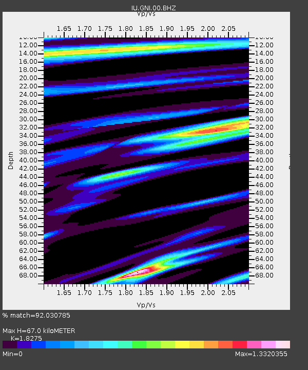
GNI Garni, Armenia - Earthquake Result Viewer
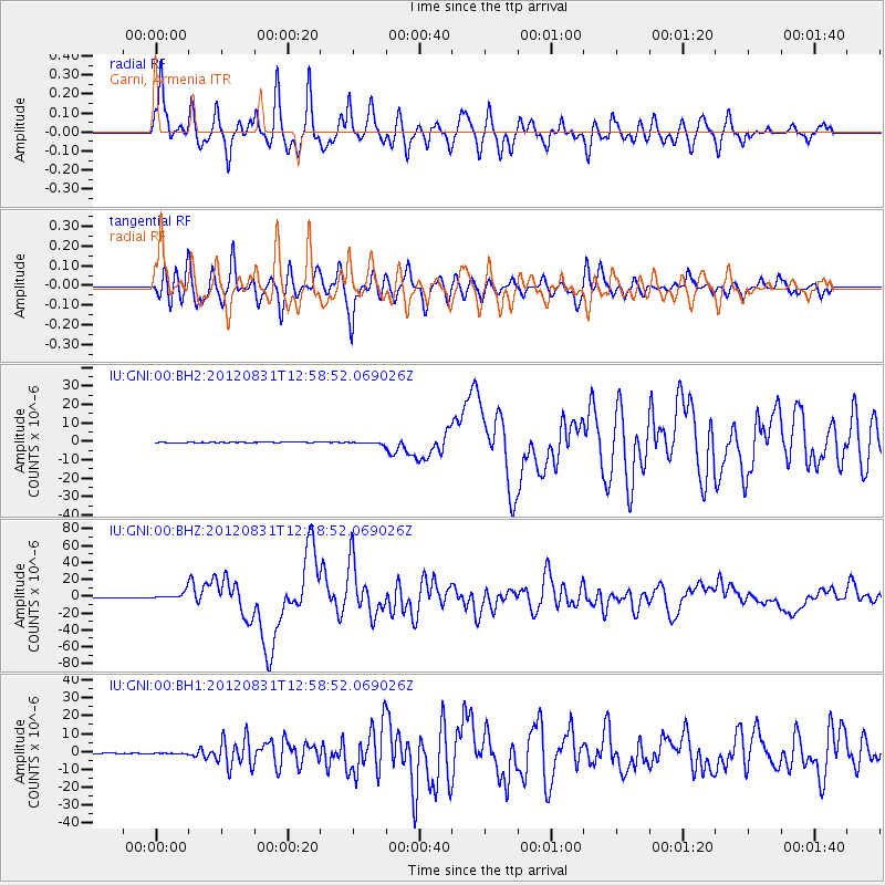
Earthquake location: Philippine Islands Region
Earthquake latitude/longitude: 10.8/126.6
Earthquake time(UTC): 2012/08/31 (244) 12:47:33 GMT
Earthquake Depth: 28 km
Earthquake Magnitude: 7.6 MW, 7.2 MB, 7.6 MS, 7.6 MW
Earthquake Catalog/Contributor: NEIC PDE/NEIC PDE-W
Network: IU Global Seismograph Network (GSN - IRIS/USGS)
Station: GNI Garni, Armenia
Lat/Lon: 40.15 N/44.74 E
Elevation: 1609 m
Distance: 76.9 deg
Az: 308.833 deg
Baz: 86.828 deg
Ray Param: 0.05061616
Estimated Moho Depth: 67.0 km
Estimated Crust Vp/Vs: 1.83
Assumed Crust Vp: 6.291 km/s
Estimated Crust Vs: 3.442 km/s
Estimated Crust Poisson's Ratio: 0.29
Radial Match: 92.030785 %
Radial Bump: 400
Transverse Match: 85.56867 %
Transverse Bump: 400
SOD ConfigId: 558545
Insert Time: 2013-09-17 16:02:36.846 +0000
GWidth: 2.5
Max Bumps: 400
Tol: 0.001

Signal To Noise

ChannelStoNSTALTA
IU:GNI:00:BHZ:20120831T12:58:52.069026Z23.7191034.257924E-61.7951456E-7
IU:GNI:00:BH1:20120831T12:58:52.069026Z1.86530391.7828502E-79.557961E-8
IU:GNI:00:BH2:20120831T12:58:52.069026Z4.40822276.602186E-71.4976979E-7
Arrivals
Ps9.1 SECOND
PpPs29 SECOND
PsPs/PpSs38 SECOND