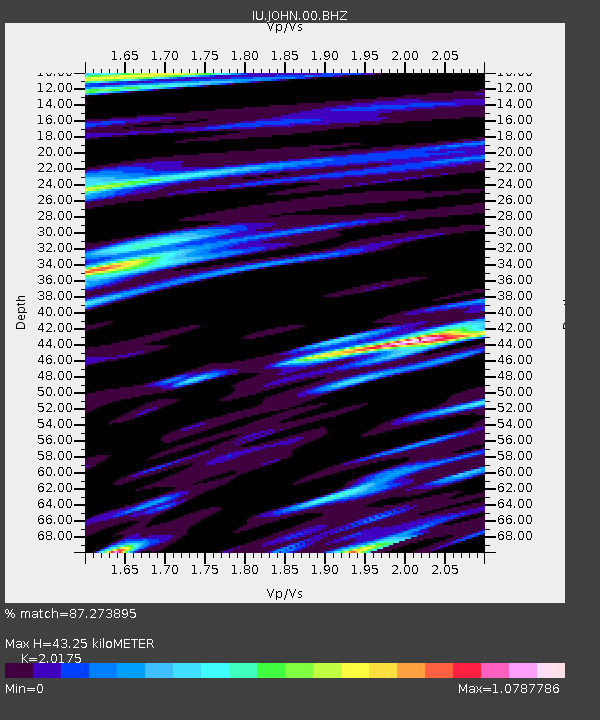
JOHN Johnston Island, USA - Earthquake Result Viewer

Earthquake location: Philippine Islands Region
Earthquake latitude/longitude: 10.8/126.6
Earthquake time(UTC): 2012/08/31 (244) 12:47:33 GMT
Earthquake Depth: 28 km
Earthquake Magnitude: 7.6 MW, 7.2 MB, 7.6 MS, 7.6 MW
Earthquake Catalog/Contributor: NEIC PDE/NEIC PDE-W
Network: IU Global Seismograph Network (GSN - IRIS/USGS)
Station: JOHN Johnston Island, USA
Lat/Lon: 16.73 N/169.53 W
Elevation: 2.0 m
Distance: 62.1 deg
Az: 76.757 deg
Baz: 273.543 deg
Ray Param: 0.060430564
Estimated Moho Depth: 43.25 km
Estimated Crust Vp/Vs: 2.02
Assumed Crust Vp: 4.24 km/s
Estimated Crust Vs: 2.102 km/s
Estimated Crust Poisson's Ratio: 0.34
Radial Match: 87.273895 %
Radial Bump: 342
Transverse Match: 76.66186 %
Transverse Bump: 400
SOD ConfigId: 558545
Insert Time: 2013-09-17 16:02:43.335 +0000
GWidth: 2.5
Max Bumps: 400
Tol: 0.001

Signal To Noise

ChannelStoNSTALTA
IU:JOHN:00:BHZ:20120831T12:57:20.468989Z22.6311632.2553333E-59.96561E-7
IU:JOHN:00:BH1:20120831T12:57:20.468989Z1.19058121.3023678E-61.0938924E-6
IU:JOHN:00:BH2:20120831T12:57:20.468989Z12.8132321.3935827E-51.0876122E-6
Arrivals
Ps11 SECOND
PpPs30 SECOND
PsPs/PpSs41 SECOND