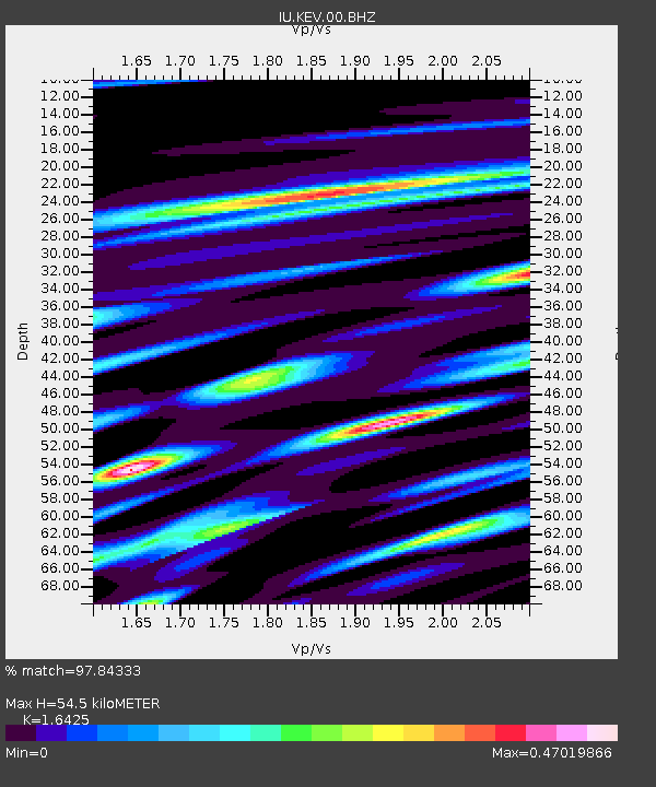
KEV Kevo, Finland - Earthquake Result Viewer
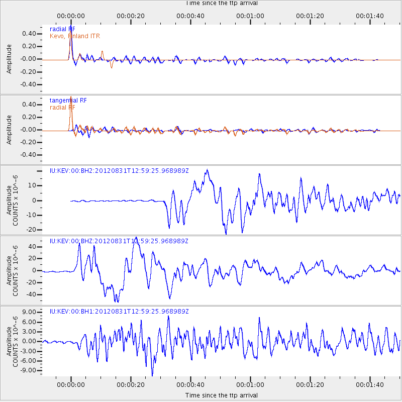
Earthquake location: Philippine Islands Region
Earthquake latitude/longitude: 10.8/126.6
Earthquake time(UTC): 2012/08/31 (244) 12:47:33 GMT
Earthquake Depth: 28 km
Earthquake Magnitude: 7.6 MW, 7.2 MB, 7.6 MS, 7.6 MW
Earthquake Catalog/Contributor: NEIC PDE/NEIC PDE-W
Network: IU Global Seismograph Network (GSN - IRIS/USGS)
Station: KEV Kevo, Finland
Lat/Lon: 69.76 N/27.00 E
Elevation: 100 m
Distance: 83.3 deg
Az: 339.785 deg
Baz: 77.259 deg
Ray Param: 0.04628553
Estimated Moho Depth: 54.5 km
Estimated Crust Vp/Vs: 1.64
Assumed Crust Vp: 6.622 km/s
Estimated Crust Vs: 4.032 km/s
Estimated Crust Poisson's Ratio: 0.21
Radial Match: 97.84333 %
Radial Bump: 335
Transverse Match: 93.21599 %
Transverse Bump: 400
SOD ConfigId: 558545
Insert Time: 2013-09-17 16:02:49.286 +0000
GWidth: 2.5
Max Bumps: 400
Tol: 0.001

Signal To Noise

ChannelStoNSTALTA
IU:KEV:00:BHZ:20120831T12:59:25.968989Z39.091451.739201E-54.4490574E-7
IU:KEV:00:BH1:20120831T12:59:25.968989Z4.01223751.1159137E-62.7812754E-7
IU:KEV:00:BH2:20120831T12:59:25.968989Z27.5542076.873918E-62.4946894E-7
Arrivals
Ps5.4 SECOND
PpPs21 SECOND
PsPs/PpSs27 SECOND