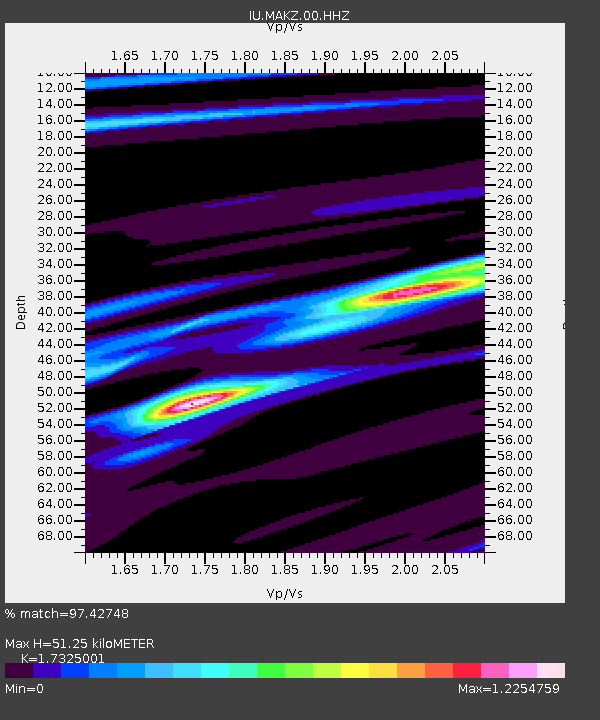
MAKZ Makanchi, Kazakhstan - Earthquake Result Viewer
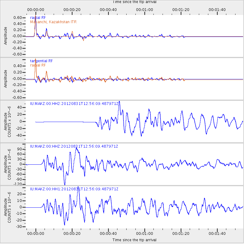
Earthquake location: Philippine Islands Region
Earthquake latitude/longitude: 10.8/126.6
Earthquake time(UTC): 2012/08/31 (244) 12:47:33 GMT
Earthquake Depth: 28 km
Earthquake Magnitude: 7.6 MW, 7.2 MB, 7.6 MS, 7.6 MW
Earthquake Catalog/Contributor: NEIC PDE/NEIC PDE-W
Network: IU Global Seismograph Network (GSN - IRIS/USGS)
Station: MAKZ Makanchi, Kazakhstan
Lat/Lon: 46.81 N/81.98 E
Elevation: 600 m
Distance: 52.0 deg
Az: 322.224 deg
Baz: 118.813 deg
Ray Param: 0.066983834
Estimated Moho Depth: 51.25 km
Estimated Crust Vp/Vs: 1.73
Assumed Crust Vp: 6.571 km/s
Estimated Crust Vs: 3.793 km/s
Estimated Crust Poisson's Ratio: 0.25
Radial Match: 97.42748 %
Radial Bump: 212
Transverse Match: 91.50228 %
Transverse Bump: 386
SOD ConfigId: 558545
Insert Time: 2013-09-17 16:03:00.341 +0000
GWidth: 2.5
Max Bumps: 400
Tol: 0.001

Signal To Noise

ChannelStoNSTALTA
IU:MAKZ:00:HHZ:20120831T12:56:09.487971Z59.7889189.712756E-61.6245077E-7
IU:MAKZ:00:HH1:20120831T12:56:09.487971Z33.1956671.9444396E-65.8575107E-8
IU:MAKZ:00:HH2:20120831T12:56:09.487971Z35.7663354.3108616E-61.2052847E-7
Arrivals
Ps6.1 SECOND
PpPs20 SECOND
PsPs/PpSs26 SECOND