You are here: Home > Network List > IU - Global Seismograph Network (GSN - IRIS/USGS) Stations List
> Station POHA Pohakuloa, Hawaii, USA > Earthquake Result Viewer
POHA Pohakuloa, Hawaii, USA - Earthquake Result Viewer
| Earthquake location: |
Philippine Islands Region |
| Earthquake latitude/longitude: |
10.8/126.6 |
| Earthquake time(UTC): |
2012/08/31 (244) 12:47:33 GMT |
| Earthquake Depth: |
28 km |
| Earthquake Magnitude: |
7.6 MW, 7.2 MB, 7.6 MS, 7.6 MW |
| Earthquake Catalog/Contributor: |
NEIC PDE/NEIC PDE-W |
|
| Network: |
IU Global Seismograph Network (GSN - IRIS/USGS) |
| Station: |
POHA Pohakuloa, Hawaii, USA |
| Lat/Lon: |
19.76 N/155.53 W |
| Elevation: |
1990 m |
|
| Distance: |
75.1 deg |
| Az: |
72.339 deg |
| Baz: |
276.294 deg |
| Ray Param: |
0.051879056 |
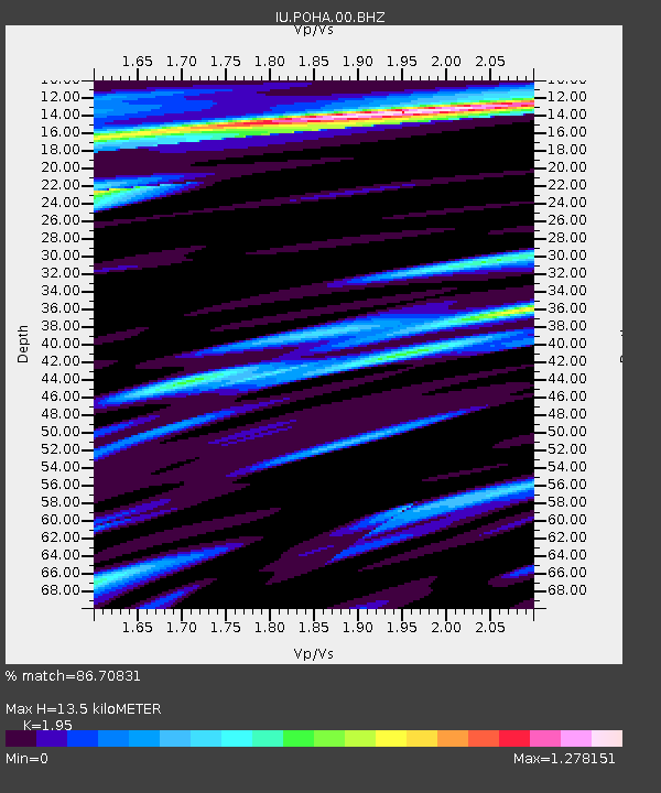
| Estimated Moho Depth: |
13.5 km |
| Estimated Crust Vp/Vs: |
1.95 |
| Assumed Crust Vp: |
5.195 km/s |
| Estimated Crust Vs: |
2.664 km/s |
| Estimated Crust Poisson's Ratio: |
0.32 |
|
| Radial Match: |
86.70831 % |
| Radial Bump: |
400 |
| Transverse Match: |
82.42233 % |
| Transverse Bump: |
400 |
| SOD ConfigId: |
558545 |
| Insert Time: |
2013-09-17 16:03:11.740 +0000 |
| GWidth: |
2.5 |
| Max Bumps: |
400 |
| Tol: |
0.001 |
|
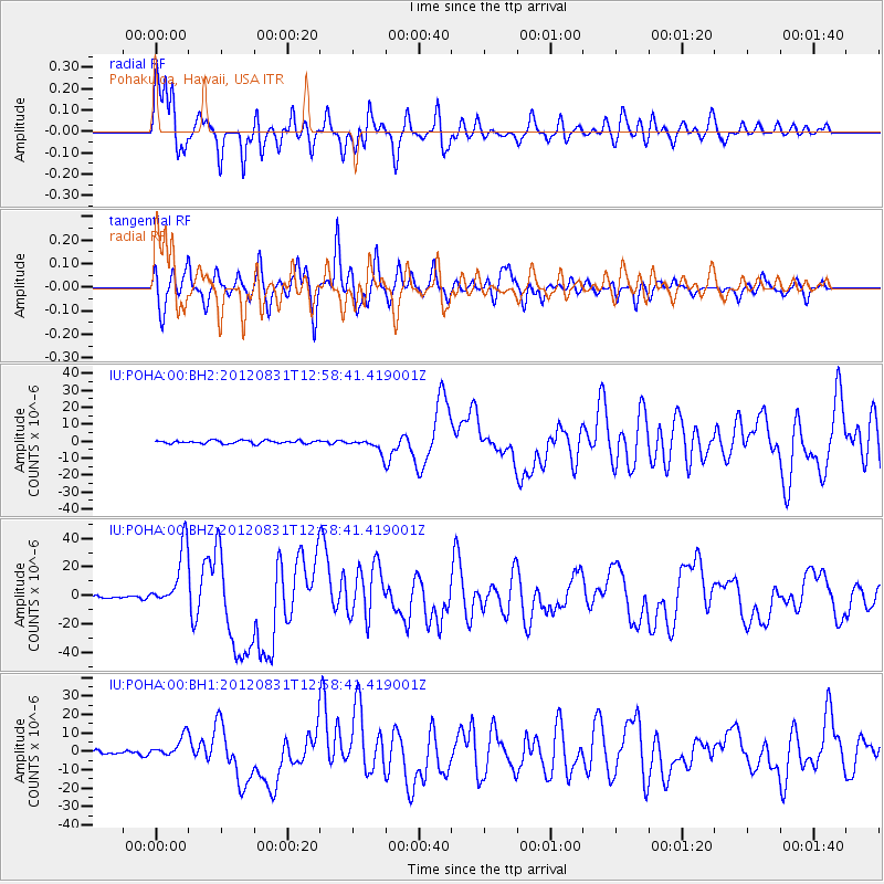
Signal To Noise
| Channel | StoN | STA | LTA |
| IU:POHA:00:BHZ:20120831T12:58:41.419001Z | 30.647943 | 2.1205911E-5 | 6.919196E-7 |
| IU:POHA:00:BH1:20120831T12:58:41.419001Z | 5.459191 | 5.873788E-6 | 1.0759447E-6 |
| IU:POHA:00:BH2:20120831T12:58:41.419001Z | 4.2331944 | 3.9325546E-6 | 9.2898046E-7 |
| Arrivals |
| Ps | 2.5 SECOND |
| PpPs | 7.5 SECOND |
| PsPs/PpSs | 10 SECOND |


