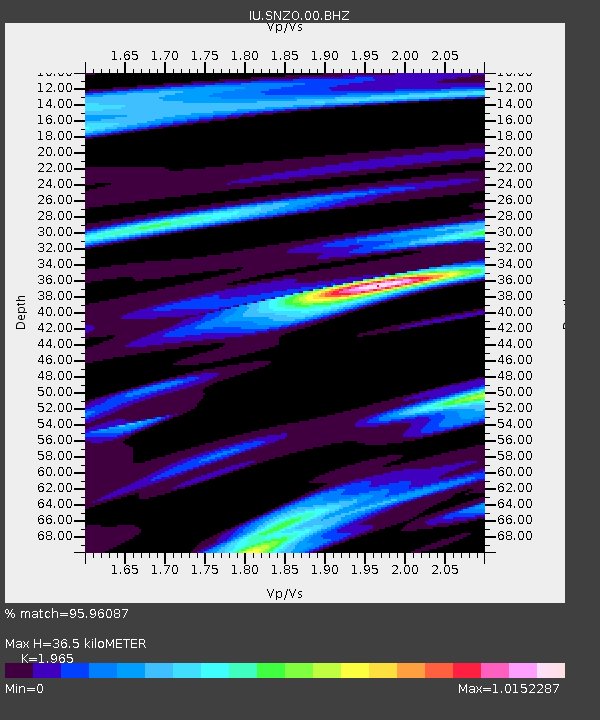
SNZO South Karori, New Zealand - Earthquake Result Viewer
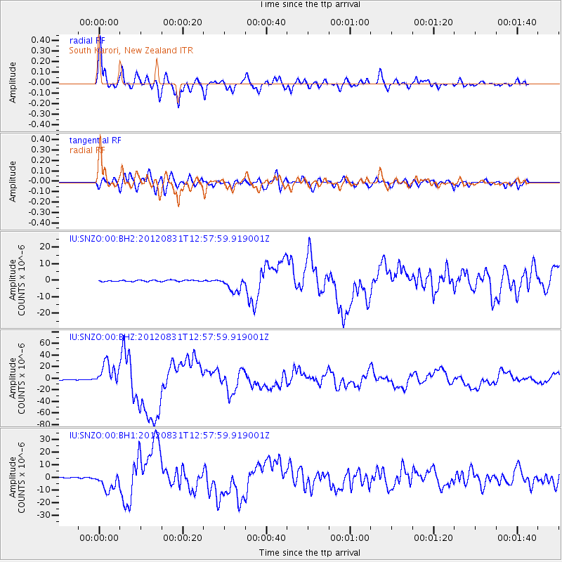
Earthquake location: Philippine Islands Region
Earthquake latitude/longitude: 10.8/126.6
Earthquake time(UTC): 2012/08/31 (244) 12:47:33 GMT
Earthquake Depth: 28 km
Earthquake Magnitude: 7.6 MW, 7.2 MB, 7.6 MS, 7.6 MW
Earthquake Catalog/Contributor: NEIC PDE/NEIC PDE-W
Network: IU Global Seismograph Network (GSN - IRIS/USGS)
Station: SNZO South Karori, New Zealand
Lat/Lon: 41.31 S/174.70 E
Elevation: 120 m
Distance: 68.2 deg
Az: 142.858 deg
Baz: 308.055 deg
Ray Param: 0.05644892
Estimated Moho Depth: 36.5 km
Estimated Crust Vp/Vs: 1.97
Assumed Crust Vp: 6.461 km/s
Estimated Crust Vs: 3.288 km/s
Estimated Crust Poisson's Ratio: 0.33
Radial Match: 95.96087 %
Radial Bump: 400
Transverse Match: 84.03168 %
Transverse Bump: 400
SOD ConfigId: 558545
Insert Time: 2013-09-17 16:03:17.938 +0000
GWidth: 2.5
Max Bumps: 400
Tol: 0.001

Signal To Noise

ChannelStoNSTALTA
IU:SNZO:00:BHZ:20120831T12:57:59.919001Z39.500212.0329588E-55.146704E-7
IU:SNZO:00:BH1:20120831T12:57:59.919001Z18.201467.2827706E-64.0012014E-7
IU:SNZO:00:BH2:20120831T12:57:59.919001Z12.52154.7777035E-63.8156E-7
Arrivals
Ps5.6 SECOND
PpPs16 SECOND
PsPs/PpSs22 SECOND