You are here: Home > Network List > US - United States National Seismic Network Stations List
> Station EGAK Eagle, Central Alaska, Alaska, USA > Earthquake Result Viewer
EGAK Eagle, Central Alaska, Alaska, USA - Earthquake Result Viewer
| Earthquake location: |
Philippine Islands Region |
| Earthquake latitude/longitude: |
10.8/126.6 |
| Earthquake time(UTC): |
2012/08/31 (244) 12:47:33 GMT |
| Earthquake Depth: |
28 km |
| Earthquake Magnitude: |
7.6 MW, 7.2 MB, 7.6 MS, 7.6 MW |
| Earthquake Catalog/Contributor: |
NEIC PDE/NEIC PDE-W |
|
| Network: |
US United States National Seismic Network |
| Station: |
EGAK Eagle, Central Alaska, Alaska, USA |
| Lat/Lon: |
64.78 N/141.16 W |
| Elevation: |
297 m |
|
| Distance: |
81.2 deg |
| Az: |
25.672 deg |
| Baz: |
276.623 deg |
| Ray Param: |
0.047686756 |
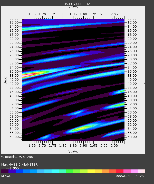
| Estimated Moho Depth: |
38.0 km |
| Estimated Crust Vp/Vs: |
1.61 |
| Assumed Crust Vp: |
6.566 km/s |
| Estimated Crust Vs: |
4.091 km/s |
| Estimated Crust Poisson's Ratio: |
0.18 |
|
| Radial Match: |
95.41269 % |
| Radial Bump: |
400 |
| Transverse Match: |
77.311714 % |
| Transverse Bump: |
400 |
| SOD ConfigId: |
558545 |
| Insert Time: |
2013-09-17 16:03:36.402 +0000 |
| GWidth: |
2.5 |
| Max Bumps: |
400 |
| Tol: |
0.001 |
|

Signal To Noise
| Channel | StoN | STA | LTA |
| US:EGAK:00:BHZ:20120831T12:59:15.499019Z | 116.97021 | 1.8970555E-5 | 1.6218279E-7 |
| US:EGAK:00:BH1:20120831T12:59:15.499019Z | 28.852106 | 2.376863E-6 | 8.2380915E-8 |
| US:EGAK:00:BH2:20120831T12:59:15.499019Z | 78.57857 | 7.0909223E-6 | 9.023991E-8 |
| Arrivals |
| Ps | 3.6 SECOND |
| PpPs | 15 SECOND |
| PsPs/PpSs | 18 SECOND |


