You are here: Home > Network List > US - United States National Seismic Network Stations List
> Station HAWA Hanford, Washington, USA > Earthquake Result Viewer
HAWA Hanford, Washington, USA - Earthquake Result Viewer
| Earthquake location: |
Philippine Islands Region |
| Earthquake latitude/longitude: |
10.8/126.6 |
| Earthquake time(UTC): |
2012/08/31 (244) 12:47:33 GMT |
| Earthquake Depth: |
28 km |
| Earthquake Magnitude: |
7.6 MW, 7.2 MB, 7.6 MS, 7.6 MW |
| Earthquake Catalog/Contributor: |
NEIC PDE/NEIC PDE-W |
|
| Network: |
US United States National Seismic Network |
| Station: |
HAWA Hanford, Washington, USA |
| Lat/Lon: |
46.39 N/119.53 W |
| Elevation: |
364 m |
|
| Distance: |
98.1 deg |
| Az: |
39.751 deg |
| Baz: |
294.811 deg |
| Ray Param: |
0.04000815 |
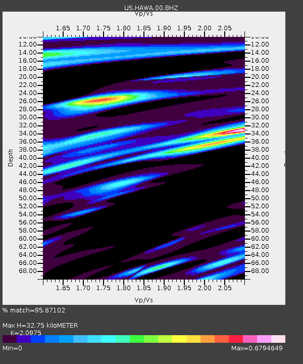
| Estimated Moho Depth: |
32.75 km |
| Estimated Crust Vp/Vs: |
2.10 |
| Assumed Crust Vp: |
6.419 km/s |
| Estimated Crust Vs: |
3.06 km/s |
| Estimated Crust Poisson's Ratio: |
0.35 |
|
| Radial Match: |
95.67102 % |
| Radial Bump: |
400 |
| Transverse Match: |
78.33086 % |
| Transverse Bump: |
400 |
| SOD ConfigId: |
558545 |
| Insert Time: |
2013-09-17 16:03:37.015 +0000 |
| GWidth: |
2.5 |
| Max Bumps: |
400 |
| Tol: |
0.001 |
|

Signal To Noise
| Channel | StoN | STA | LTA |
| US:HAWA:00:BHZ:20120831T13:00:35.549006Z | 32.889233 | 5.036159E-6 | 1.5312487E-7 |
| US:HAWA:00:BH1:20120831T13:00:35.549006Z | 9.207696 | 6.975766E-7 | 7.576016E-8 |
| US:HAWA:00:BH2:20120831T13:00:35.549006Z | 9.80465 | 1.0331768E-6 | 1.05376195E-7 |
| Arrivals |
| Ps | 5.7 SECOND |
| PpPs | 16 SECOND |
| PsPs/PpSs | 21 SECOND |


