You are here: Home > Network List > US - United States National Seismic Network Stations List
> Station NLWA Neilton Lookout, Washington, USA > Earthquake Result Viewer
NLWA Neilton Lookout, Washington, USA - Earthquake Result Viewer
| Earthquake location: |
Philippine Islands Region |
| Earthquake latitude/longitude: |
10.8/126.6 |
| Earthquake time(UTC): |
2012/08/31 (244) 12:47:33 GMT |
| Earthquake Depth: |
28 km |
| Earthquake Magnitude: |
7.6 MW, 7.2 MB, 7.6 MS, 7.6 MW |
| Earthquake Catalog/Contributor: |
NEIC PDE/NEIC PDE-W |
|
| Network: |
US United States National Seismic Network |
| Station: |
NLWA Neilton Lookout, Washington, USA |
| Lat/Lon: |
47.39 N/123.87 W |
| Elevation: |
640 m |
|
| Distance: |
94.9 deg |
| Az: |
40.007 deg |
| Baz: |
291.625 deg |
| Ray Param: |
0.040904902 |
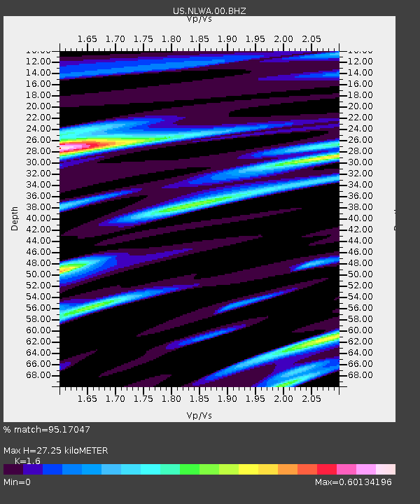
| Estimated Moho Depth: |
27.25 km |
| Estimated Crust Vp/Vs: |
1.60 |
| Assumed Crust Vp: |
6.566 km/s |
| Estimated Crust Vs: |
4.104 km/s |
| Estimated Crust Poisson's Ratio: |
0.18 |
|
| Radial Match: |
95.17047 % |
| Radial Bump: |
400 |
| Transverse Match: |
88.55072 % |
| Transverse Bump: |
400 |
| SOD ConfigId: |
558545 |
| Insert Time: |
2013-09-17 16:03:43.138 +0000 |
| GWidth: |
2.5 |
| Max Bumps: |
400 |
| Tol: |
0.001 |
|
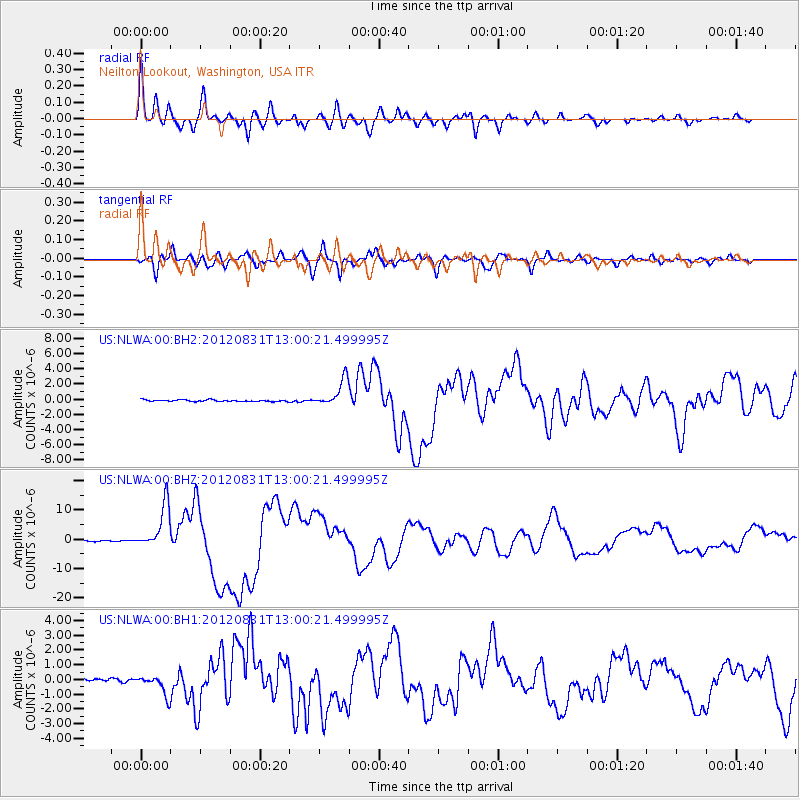
Signal To Noise
| Channel | StoN | STA | LTA |
| US:NLWA:00:BHZ:20120831T13:00:21.499995Z | 54.91466 | 7.4859486E-6 | 1.3631967E-7 |
| US:NLWA:00:BH1:20120831T13:00:21.499995Z | 6.4098325 | 6.844947E-7 | 1.06788235E-7 |
| US:NLWA:00:BH2:20120831T13:00:21.499995Z | 16.745707 | 1.7590513E-6 | 1.0504492E-7 |
| Arrivals |
| Ps | 2.5 SECOND |
| PpPs | 11 SECOND |
| PsPs/PpSs | 13 SECOND |


