You are here: Home > Network List > US - United States National Seismic Network Stations List
> Station WRAK Wrangell Island, Southeastern Alaska, Alaska, USA > Earthquake Result Viewer
WRAK Wrangell Island, Southeastern Alaska, Alaska, USA - Earthquake Result Viewer
| Earthquake location: |
Philippine Islands Region |
| Earthquake latitude/longitude: |
10.8/126.6 |
| Earthquake time(UTC): |
2012/08/31 (244) 12:47:33 GMT |
| Earthquake Depth: |
28 km |
| Earthquake Magnitude: |
7.6 MW, 7.2 MB, 7.6 MS, 7.6 MW |
| Earthquake Catalog/Contributor: |
NEIC PDE/NEIC PDE-W |
|
| Network: |
US United States National Seismic Network |
| Station: |
WRAK Wrangell Island, Southeastern Alaska, Alaska, USA |
| Lat/Lon: |
56.42 N/132.35 W |
| Elevation: |
81 m |
|
| Distance: |
87.1 deg |
| Az: |
33.104 deg |
| Baz: |
285.068 deg |
| Ray Param: |
0.043536086 |
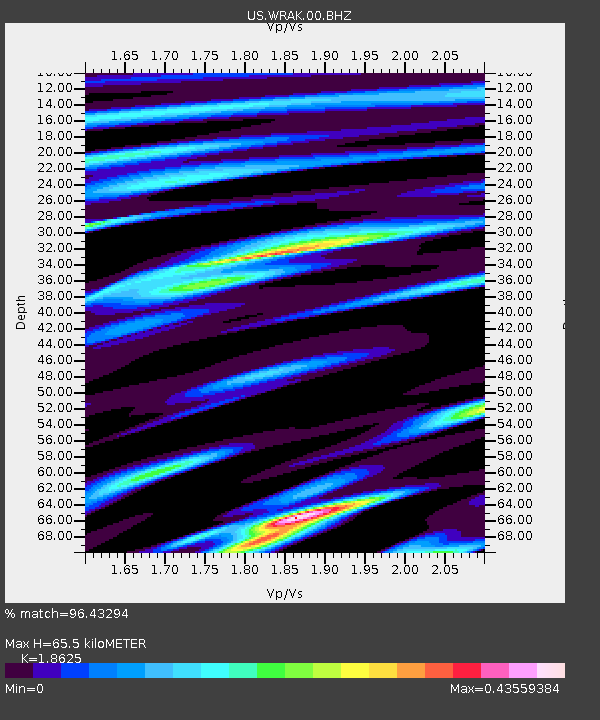
| Estimated Moho Depth: |
65.5 km |
| Estimated Crust Vp/Vs: |
1.86 |
| Assumed Crust Vp: |
6.597 km/s |
| Estimated Crust Vs: |
3.542 km/s |
| Estimated Crust Poisson's Ratio: |
0.30 |
|
| Radial Match: |
96.43294 % |
| Radial Bump: |
400 |
| Transverse Match: |
86.33906 % |
| Transverse Bump: |
400 |
| SOD ConfigId: |
558545 |
| Insert Time: |
2013-09-17 16:03:43.502 +0000 |
| GWidth: |
2.5 |
| Max Bumps: |
400 |
| Tol: |
0.001 |
|
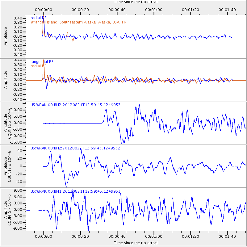
Signal To Noise
| Channel | StoN | STA | LTA |
| US:WRAK:00:BHZ:20120831T12:59:45.124995Z | 151.36493 | 1.6179838E-5 | 1.0689291E-7 |
| US:WRAK:00:BH1:20120831T12:59:45.124995Z | 25.012278 | 1.7825737E-6 | 7.126795E-8 |
| US:WRAK:00:BH2:20120831T12:59:45.124995Z | 58.152584 | 4.8190295E-6 | 8.286871E-8 |
| Arrivals |
| Ps | 8.8 SECOND |
| PpPs | 28 SECOND |
| PsPs/PpSs | 37 SECOND |


