You are here: Home > Network List > UW - Pacific Northwest Regional Seismic Network Stations List
> Station TUCA Wood Farm, Starbuck, WA, USA > Earthquake Result Viewer
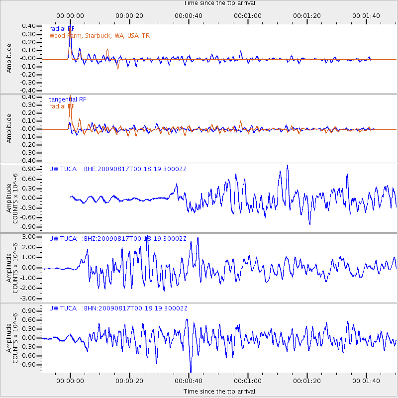
TUCA Wood Farm, Starbuck, WA, USA - Earthquake Result Viewer

| Earthquake location: |
Southwestern Ryukyu Isl., Japan |
| Earthquake latitude/longitude: |
23.5/123.5 |
| Earthquake time(UTC): |
2009/08/17 (229) 00:05:49 GMT |
| Earthquake Depth: |
20 km |
| Earthquake Magnitude: |
6.2 MB, 6.6 MS, 6.7 MW, 6.6 MW |
| Earthquake Catalog/Contributor: |
WHDF/NEIC |
|
| Network: |
UW Pacific Northwest Regional Seismic Network |
| Station: |
TUCA Wood Farm, Starbuck, WA, USA |
| Lat/Lon: |
46.51 N/118.15 W |
| Elevation: |
304 m |
|
| Distance: |
90.8 deg |
| Az: |
37.431 deg |
| Baz: |
306.103 deg |
| Ray Param: |
0.04164441 |
| Estimated Moho Depth: |
31.0 km |
| Estimated Crust Vp/Vs: |
1.67 |
| Assumed Crust Vp: |
6.419 km/s |
| Estimated Crust Vs: |
3.85 km/s |
| Estimated Crust Poisson's Ratio: |
0.22 |
|
| Radial Match: |
96.32891 % |
| Radial Bump: |
400 |
| Transverse Match: |
88.03437 % |
| Transverse Bump: |
400 |
| SOD ConfigId: |
2622 |
| Insert Time: |
2010-02-27 05:13:00.929 +0000 |
| GWidth: |
2.5 |
| Max Bumps: |
400 |
| Tol: |
0.001 |
|
Signal To Noise
| Channel | StoN | STA | LTA |
| UW:TUCA: :BHZ:20090817T00:18:19.30002Z | 11.528257 | 3.800385E-7 | 3.2965822E-8 |
| UW:TUCA: :BHN:20090817T00:18:19.30002Z | 2.0831764 | 8.519646E-8 | 4.0897383E-8 |
| UW:TUCA: :BHE:20090817T00:18:19.30002Z | 1.5209602 | 8.768384E-8 | 5.765032E-8 |
| Arrivals |
| Ps | 3.3 SECOND |
| PpPs | 13 SECOND |
| PsPs/PpSs | 16 SECOND |


