You are here: Home > Network List > US - United States National Seismic Network Stations List
> Station GLMI Grayling, Michigan, USA > Earthquake Result Viewer
GLMI Grayling, Michigan, USA - Earthquake Result Viewer
| Earthquake location: |
Jan Mayen Island Region |
| Earthquake latitude/longitude: |
71.4/-10.6 |
| Earthquake time(UTC): |
2012/08/30 (243) 13:43:25 GMT |
| Earthquake Depth: |
14 km |
| Earthquake Magnitude: |
6.7 MW, 5.9 MB, 6.3 MS, 6.8 MW |
| Earthquake Catalog/Contributor: |
NEIC PDE/NEIC PDE-W |
|
| Network: |
US United States National Seismic Network |
| Station: |
GLMI Grayling, Michigan, USA |
| Lat/Lon: |
44.82 N/84.62 W |
| Elevation: |
387 m |
|
| Distance: |
43.3 deg |
| Az: |
273.286 deg |
| Baz: |
26.694 deg |
| Ray Param: |
0.07265995 |
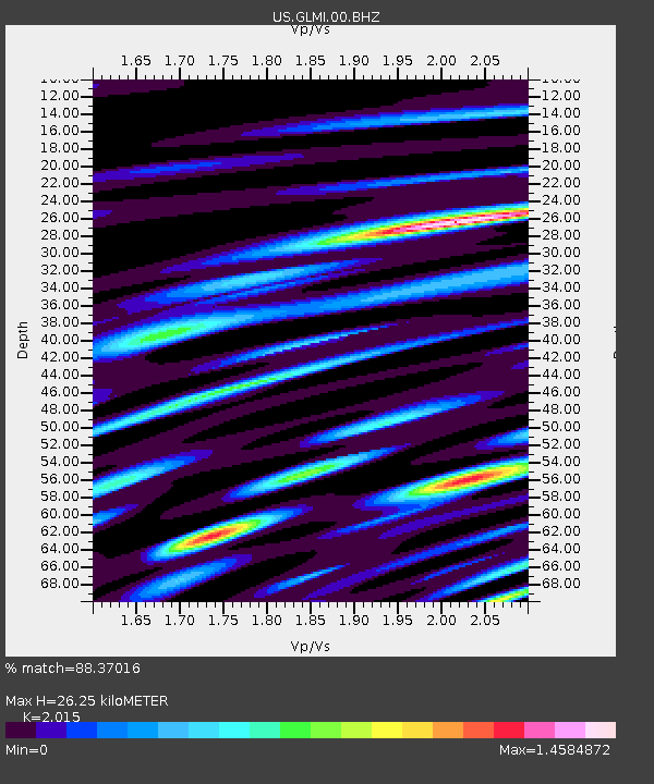
| Estimated Moho Depth: |
26.25 km |
| Estimated Crust Vp/Vs: |
2.02 |
| Assumed Crust Vp: |
6.483 km/s |
| Estimated Crust Vs: |
3.217 km/s |
| Estimated Crust Poisson's Ratio: |
0.34 |
|
| Radial Match: |
88.37016 % |
| Radial Bump: |
400 |
| Transverse Match: |
83.87552 % |
| Transverse Bump: |
400 |
| SOD ConfigId: |
558545 |
| Insert Time: |
2013-09-17 16:04:35.631 +0000 |
| GWidth: |
2.5 |
| Max Bumps: |
400 |
| Tol: |
0.001 |
|

Signal To Noise
| Channel | StoN | STA | LTA |
| US:GLMI:00:BHZ:20120830T13:50:55.12401Z | 2.6830802 | 9.262694E-7 | 3.452261E-7 |
| US:GLMI:00:BH1:20120830T13:50:55.12401Z | 0.84430575 | 4.2588323E-7 | 5.0441827E-7 |
| US:GLMI:00:BH2:20120830T13:50:55.12401Z | 0.9569428 | 3.9195393E-7 | 4.0958972E-7 |
| Arrivals |
| Ps | 4.4 SECOND |
| PpPs | 12 SECOND |
| PsPs/PpSs | 16 SECOND |


