You are here: Home > Network List > US - United States National Seismic Network Stations List
> Station HAWA Hanford, Washington, USA > Earthquake Result Viewer
HAWA Hanford, Washington, USA - Earthquake Result Viewer

| Earthquake location: |
Jan Mayen Island Region |
| Earthquake latitude/longitude: |
71.4/-10.6 |
| Earthquake time(UTC): |
2012/08/30 (243) 13:43:25 GMT |
| Earthquake Depth: |
14 km |
| Earthquake Magnitude: |
6.7 MW, 5.9 MB, 6.3 MS, 6.8 MW |
| Earthquake Catalog/Contributor: |
NEIC PDE/NEIC PDE-W |
|
| Network: |
US United States National Seismic Network |
| Station: |
HAWA Hanford, Washington, USA |
| Lat/Lon: |
46.39 N/119.53 W |
| Elevation: |
364 m |
|
| Distance: |
52.3 deg |
| Az: |
304.132 deg |
| Baz: |
22.516 deg |
| Ray Param: |
0.06685395 |
| Estimated Moho Depth: |
34.0 km |
| Estimated Crust Vp/Vs: |
1.68 |
| Assumed Crust Vp: |
6.419 km/s |
| Estimated Crust Vs: |
3.827 km/s |
| Estimated Crust Poisson's Ratio: |
0.22 |
|
| Radial Match: |
93.86005 % |
| Radial Bump: |
400 |
| Transverse Match: |
71.55097 % |
| Transverse Bump: |
400 |
| SOD ConfigId: |
558545 |
| Insert Time: |
2013-09-17 16:04:42.033 +0000 |
| GWidth: |
2.5 |
| Max Bumps: |
400 |
| Tol: |
0.001 |
|
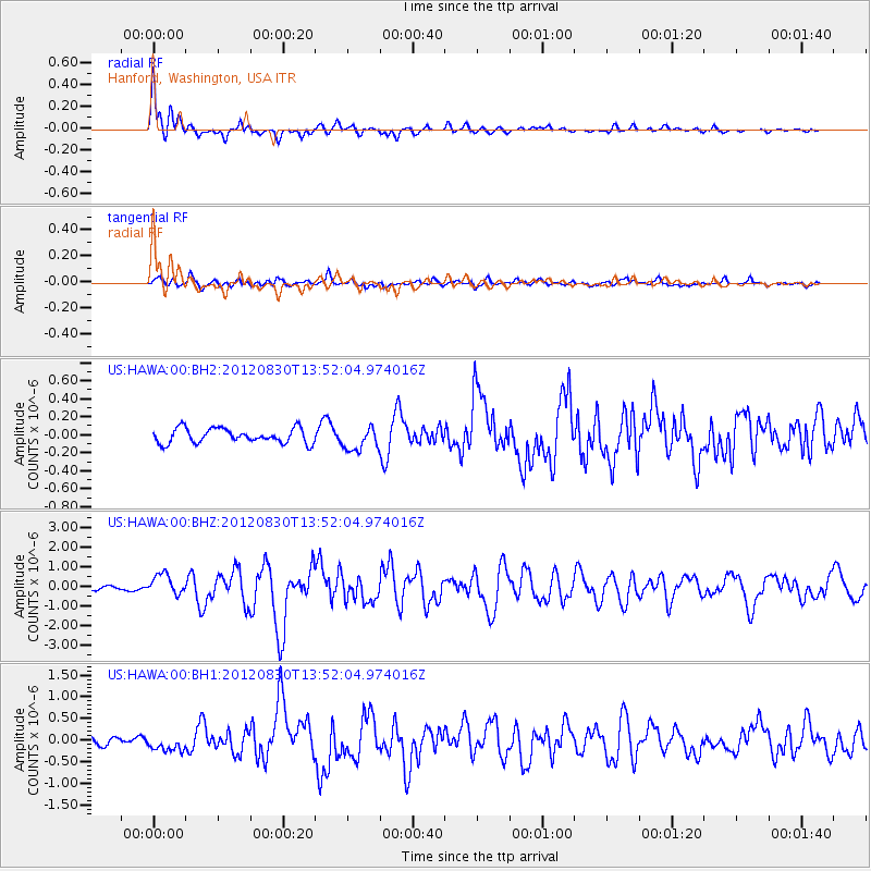
Signal To Noise
| Channel | StoN | STA | LTA |
| US:HAWA:00:BHZ:20120830T13:52:04.974016Z | 4.362679 | 5.3045784E-7 | 1.2158992E-7 |
| US:HAWA:00:BH1:20120830T13:52:04.974016Z | 2.4699447 | 1.8831935E-7 | 7.6244355E-8 |
| US:HAWA:00:BH2:20120830T13:52:04.974016Z | 1.631188 | 1.3138134E-7 | 8.054335E-8 |
| Arrivals |
| Ps | 3.8 SECOND |
| PpPs | 13 SECOND |
| PsPs/PpSs | 17 SECOND |


