You are here: Home > Network List > US - United States National Seismic Network Stations List
> Station MSO Missoula, Montana, USA > Earthquake Result Viewer
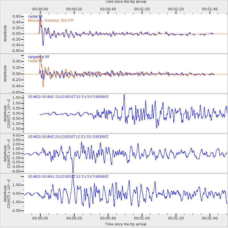
MSO Missoula, Montana, USA - Earthquake Result Viewer

| Earthquake location: |
Jan Mayen Island Region |
| Earthquake latitude/longitude: |
71.4/-10.6 |
| Earthquake time(UTC): |
2012/08/30 (243) 13:43:25 GMT |
| Earthquake Depth: |
14 km |
| Earthquake Magnitude: |
6.7 MW, 5.9 MB, 6.3 MS, 6.8 MW |
| Earthquake Catalog/Contributor: |
NEIC PDE/NEIC PDE-W |
|
| Network: |
US United States National Seismic Network |
| Station: |
MSO Missoula, Montana, USA |
| Lat/Lon: |
46.83 N/113.94 W |
| Elevation: |
1264 m |
|
| Distance: |
50.4 deg |
| Az: |
299.813 deg |
| Baz: |
23.868 deg |
| Ray Param: |
0.06810285 |
| Estimated Moho Depth: |
36.75 km |
| Estimated Crust Vp/Vs: |
1.79 |
| Assumed Crust Vp: |
6.353 km/s |
| Estimated Crust Vs: |
3.549 km/s |
| Estimated Crust Poisson's Ratio: |
0.27 |
|
| Radial Match: |
93.31763 % |
| Radial Bump: |
400 |
| Transverse Match: |
84.78525 % |
| Transverse Bump: |
400 |
| SOD ConfigId: |
558545 |
| Insert Time: |
2013-09-17 16:05:21.984 +0000 |
| GWidth: |
2.5 |
| Max Bumps: |
400 |
| Tol: |
0.001 |
|
Signal To Noise
| Channel | StoN | STA | LTA |
| US:MSO:00:BHZ:20120830T13:51:50.598986Z | 4.5423408 | 5.311038E-7 | 1.16922934E-7 |
| US:MSO:00:BH1:20120830T13:51:50.598986Z | 2.843101 | 2.8053566E-7 | 9.8672416E-8 |
| US:MSO:00:BH2:20120830T13:51:50.598986Z | 2.3822157 | 1.9988362E-7 | 8.390659E-8 |
| Arrivals |
| Ps | 4.8 SECOND |
| PpPs | 15 SECOND |
| PsPs/PpSs | 20 SECOND |


