You are here: Home > Network List > US - United States National Seismic Network Stations List
> Station SCIA State Center, Iowa, USA > Earthquake Result Viewer
SCIA State Center, Iowa, USA - Earthquake Result Viewer

| Earthquake location: |
Jan Mayen Island Region |
| Earthquake latitude/longitude: |
71.4/-10.6 |
| Earthquake time(UTC): |
2012/08/30 (243) 13:43:25 GMT |
| Earthquake Depth: |
14 km |
| Earthquake Magnitude: |
6.7 MW, 5.9 MB, 6.3 MS, 6.8 MW |
| Earthquake Catalog/Contributor: |
NEIC PDE/NEIC PDE-W |
|
| Network: |
US United States National Seismic Network |
| Station: |
SCIA State Center, Iowa, USA |
| Lat/Lon: |
41.91 N/93.22 W |
| Elevation: |
312 m |
|
| Distance: |
48.6 deg |
| Az: |
279.368 deg |
| Baz: |
25.04 deg |
| Ray Param: |
0.069234565 |
| Estimated Moho Depth: |
47.0 km |
| Estimated Crust Vp/Vs: |
1.71 |
| Assumed Crust Vp: |
6.498 km/s |
| Estimated Crust Vs: |
3.794 km/s |
| Estimated Crust Poisson's Ratio: |
0.24 |
|
| Radial Match: |
91.40085 % |
| Radial Bump: |
294 |
| Transverse Match: |
75.033646 % |
| Transverse Bump: |
400 |
| SOD ConfigId: |
558545 |
| Insert Time: |
2013-09-17 16:05:54.258 +0000 |
| GWidth: |
2.5 |
| Max Bumps: |
400 |
| Tol: |
0.001 |
|
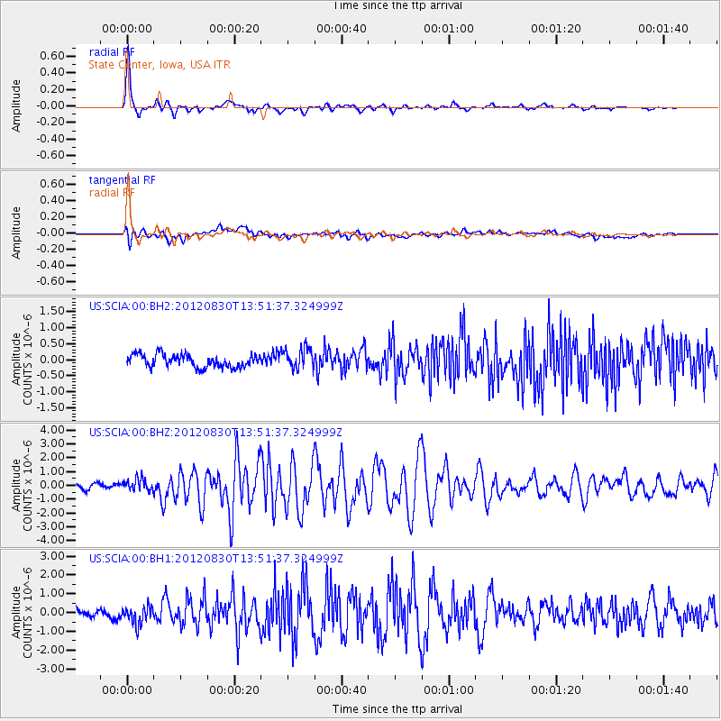
Signal To Noise
| Channel | StoN | STA | LTA |
| US:SCIA:00:BHZ:20120830T13:51:37.324999Z | 2.2352166 | 4.2824655E-7 | 1.9159063E-7 |
| US:SCIA:00:BH1:20120830T13:51:37.324999Z | 1.9569453 | 4.7322416E-7 | 2.4181776E-7 |
| US:SCIA:00:BH2:20120830T13:51:37.324999Z | 1.6776412 | 3.3383265E-7 | 1.9898931E-7 |
| Arrivals |
| Ps | 5.5 SECOND |
| PpPs | 18 SECOND |
| PsPs/PpSs | 24 SECOND |


