You are here: Home > Network List > US - United States National Seismic Network Stations List
> Station AGMN Agassiz National Wildlife Refuge, Minnesota, USA > Earthquake Result Viewer
AGMN Agassiz National Wildlife Refuge, Minnesota, USA - Earthquake Result Viewer
| Earthquake location: |
Peru-Brazil Border Region |
| Earthquake latitude/longitude: |
-8.4/-74.3 |
| Earthquake time(UTC): |
2012/08/02 (215) 09:38:30 GMT |
| Earthquake Depth: |
145 km |
| Earthquake Magnitude: |
5.9 MB, 6.1 MW, 6.1 MW |
| Earthquake Catalog/Contributor: |
WHDF/NEIC |
|
| Network: |
US United States National Seismic Network |
| Station: |
AGMN Agassiz National Wildlife Refuge, Minnesota, USA |
| Lat/Lon: |
48.30 N/95.86 W |
| Elevation: |
351 m |
|
| Distance: |
59.6 deg |
| Az: |
343.439 deg |
| Baz: |
155.018 deg |
| Ray Param: |
0.061639316 |
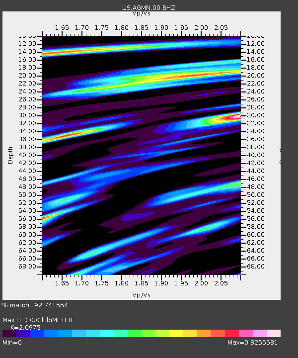
| Estimated Moho Depth: |
30.0 km |
| Estimated Crust Vp/Vs: |
2.10 |
| Assumed Crust Vp: |
6.419 km/s |
| Estimated Crust Vs: |
3.06 km/s |
| Estimated Crust Poisson's Ratio: |
0.35 |
|
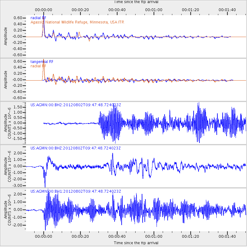
| Radial Match: |
92.741554 % |
| Radial Bump: |
400 |
| Transverse Match: |
74.17946 % |
| Transverse Bump: |
400 |
| SOD ConfigId: |
558545 |
| Insert Time: |
2013-09-17 16:09:58.085 +0000 |
| GWidth: |
2.5 |
| Max Bumps: |
400 |
| Tol: |
0.001 |
|
Signal To Noise
| Channel | StoN | STA | LTA |
| US:AGMN:00:BHZ:20120802T09:47:48.724023Z | 21.221207 | 1.1420619E-6 | 5.381701E-8 |
| US:AGMN:00:BH1:20120802T09:47:48.724023Z | 21.501509 | 1.1373893E-6 | 5.2898116E-8 |
| US:AGMN:00:BH2:20120802T09:47:48.724023Z | 16.547388 | 6.3964507E-7 | 3.8655347E-8 |
| Arrivals |
| Ps | 5.3 SECOND |
| PpPs | 14 SECOND |
| PsPs/PpSs | 19 SECOND |


