You are here: Home > Network List > US - United States National Seismic Network Stations List
> Station COWI Conover, Wisconsin, USA > Earthquake Result Viewer
COWI Conover, Wisconsin, USA - Earthquake Result Viewer

| Earthquake location: |
Peru-Brazil Border Region |
| Earthquake latitude/longitude: |
-8.4/-74.3 |
| Earthquake time(UTC): |
2012/08/02 (215) 09:38:30 GMT |
| Earthquake Depth: |
145 km |
| Earthquake Magnitude: |
5.9 MB, 6.1 MW, 6.1 MW |
| Earthquake Catalog/Contributor: |
WHDF/NEIC |
|
| Network: |
US United States National Seismic Network |
| Station: |
COWI Conover, Wisconsin, USA |
| Lat/Lon: |
46.10 N/89.14 W |
| Elevation: |
523 m |
|
| Distance: |
55.9 deg |
| Az: |
347.537 deg |
| Baz: |
162.13 deg |
| Ray Param: |
0.064041756 |
| Estimated Moho Depth: |
41.75 km |
| Estimated Crust Vp/Vs: |
1.75 |
| Assumed Crust Vp: |
6.467 km/s |
| Estimated Crust Vs: |
3.685 km/s |
| Estimated Crust Poisson's Ratio: |
0.26 |
|
| Radial Match: |
91.22855 % |
| Radial Bump: |
400 |
| Transverse Match: |
68.320526 % |
| Transverse Bump: |
400 |
| SOD ConfigId: |
558545 |
| Insert Time: |
2013-09-17 16:10:28.887 +0000 |
| GWidth: |
2.5 |
| Max Bumps: |
400 |
| Tol: |
0.001 |
|
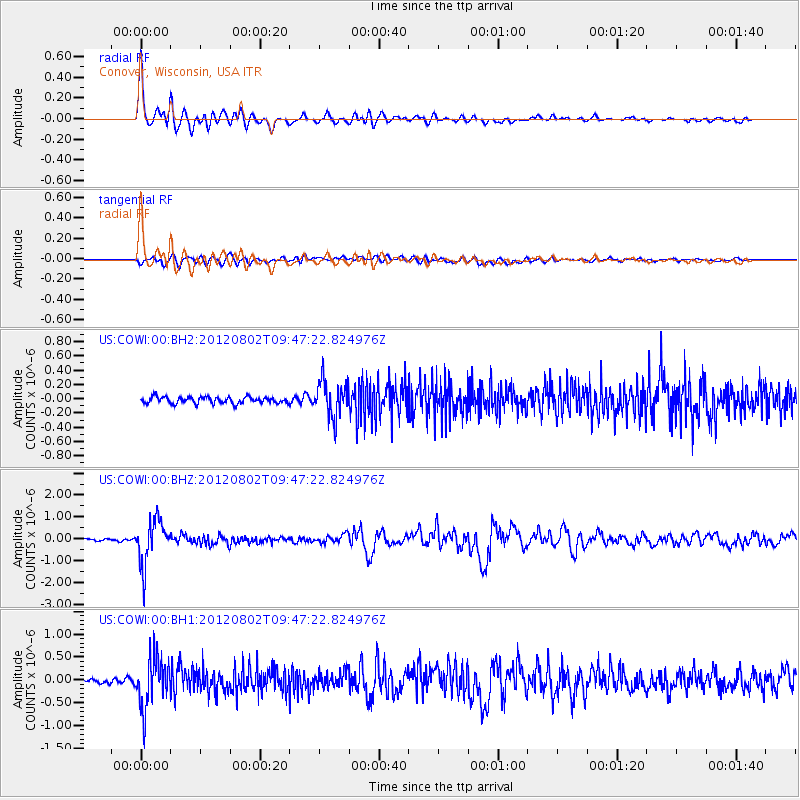
Signal To Noise
| Channel | StoN | STA | LTA |
| US:COWI:00:BHZ:20120802T09:47:22.824976Z | 15.711934 | 1.0209992E-6 | 6.49824E-8 |
| US:COWI:00:BH1:20120802T09:47:22.824976Z | 10.552105 | 5.4854286E-7 | 5.1984212E-8 |
| US:COWI:00:BH2:20120802T09:47:22.824976Z | 5.597534 | 2.5566828E-7 | 4.5675165E-8 |
| Arrivals |
| Ps | 5.1 SECOND |
| PpPs | 17 SECOND |
| PsPs/PpSs | 22 SECOND |


