You are here: Home > Network List > US - United States National Seismic Network Stations List
> Station GOGA Godfrey, Georgia, USA > Earthquake Result Viewer
GOGA Godfrey, Georgia, USA - Earthquake Result Viewer
| Earthquake location: |
Peru-Brazil Border Region |
| Earthquake latitude/longitude: |
-8.4/-74.3 |
| Earthquake time(UTC): |
2012/08/02 (215) 09:38:30 GMT |
| Earthquake Depth: |
145 km |
| Earthquake Magnitude: |
5.9 MB, 6.1 MW, 6.1 MW |
| Earthquake Catalog/Contributor: |
WHDF/NEIC |
|
| Network: |
US United States National Seismic Network |
| Station: |
GOGA Godfrey, Georgia, USA |
| Lat/Lon: |
33.41 N/83.47 W |
| Elevation: |
150 m |
|
| Distance: |
42.5 deg |
| Az: |
348.575 deg |
| Baz: |
166.449 deg |
| Ray Param: |
0.07260477 |
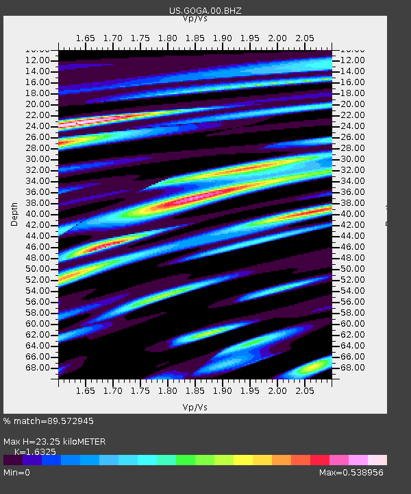
| Estimated Moho Depth: |
23.25 km |
| Estimated Crust Vp/Vs: |
1.63 |
| Assumed Crust Vp: |
6.565 km/s |
| Estimated Crust Vs: |
4.021 km/s |
| Estimated Crust Poisson's Ratio: |
0.20 |
|
| Radial Match: |
89.572945 % |
| Radial Bump: |
400 |
| Transverse Match: |
72.48886 % |
| Transverse Bump: |
400 |
| SOD ConfigId: |
558545 |
| Insert Time: |
2013-09-17 16:11:02.656 +0000 |
| GWidth: |
2.5 |
| Max Bumps: |
400 |
| Tol: |
0.001 |
|

Signal To Noise
| Channel | StoN | STA | LTA |
| US:GOGA:00:BHZ:20120802T09:45:41.425012Z | 15.610962 | 1.01563E-6 | 6.505877E-8 |
| US:GOGA:00:BH1:20120802T09:45:41.425012Z | 7.341385 | 3.2609995E-7 | 4.4419405E-8 |
| US:GOGA:00:BH2:20120802T09:45:41.425012Z | 9.77909 | 4.4377128E-7 | 4.537961E-8 |
| Arrivals |
| Ps | 2.4 SECOND |
| PpPs | 8.6 SECOND |
| PsPs/PpSs | 11 SECOND |


