You are here: Home > Network List > US - United States National Seismic Network Stations List
> Station ISCO Idaho Springs, Colorado, USA > Earthquake Result Viewer
ISCO Idaho Springs, Colorado, USA - Earthquake Result Viewer
| Earthquake location: |
Peru-Brazil Border Region |
| Earthquake latitude/longitude: |
-8.4/-74.3 |
| Earthquake time(UTC): |
2012/08/02 (215) 09:38:30 GMT |
| Earthquake Depth: |
145 km |
| Earthquake Magnitude: |
5.9 MB, 6.1 MW, 6.1 MW |
| Earthquake Catalog/Contributor: |
WHDF/NEIC |
|
| Network: |
US United States National Seismic Network |
| Station: |
ISCO Idaho Springs, Colorado, USA |
| Lat/Lon: |
39.80 N/105.61 W |
| Elevation: |
2743 m |
|
| Distance: |
56.1 deg |
| Az: |
331.109 deg |
| Baz: |
141.649 deg |
| Ray Param: |
0.063919604 |
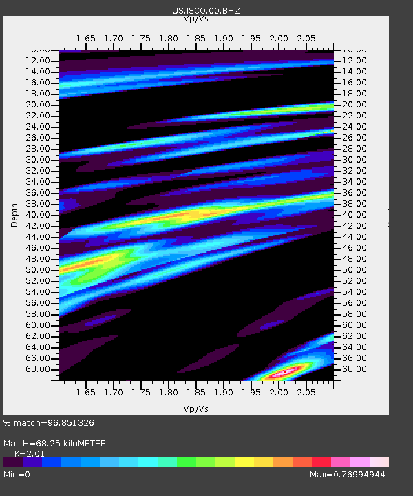
| Estimated Moho Depth: |
68.25 km |
| Estimated Crust Vp/Vs: |
2.01 |
| Assumed Crust Vp: |
6.159 km/s |
| Estimated Crust Vs: |
3.064 km/s |
| Estimated Crust Poisson's Ratio: |
0.34 |
|
| Radial Match: |
96.851326 % |
| Radial Bump: |
285 |
| Transverse Match: |
86.655846 % |
| Transverse Bump: |
400 |
| SOD ConfigId: |
558545 |
| Insert Time: |
2013-09-17 16:11:12.841 +0000 |
| GWidth: |
2.5 |
| Max Bumps: |
400 |
| Tol: |
0.001 |
|
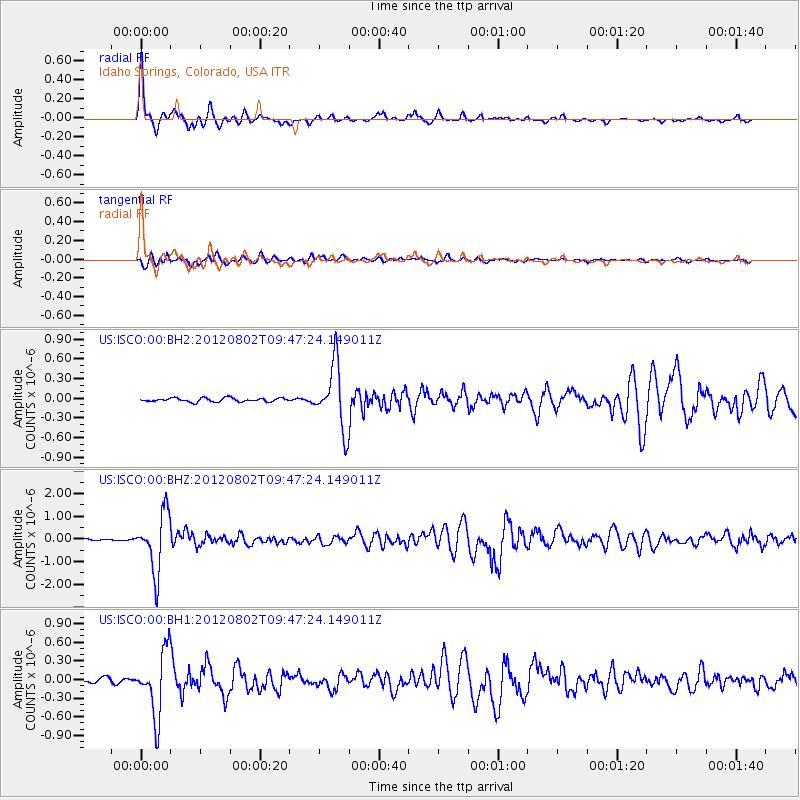
Signal To Noise
| Channel | StoN | STA | LTA |
| US:ISCO:00:BHZ:20120802T09:47:24.149011Z | 38.57607 | 1.2755321E-6 | 3.306537E-8 |
| US:ISCO:00:BH1:20120802T09:47:24.149011Z | 13.472771 | 5.166747E-7 | 3.8349548E-8 |
| US:ISCO:00:BH2:20120802T09:47:24.149011Z | 16.99147 | 4.888531E-7 | 2.87705E-8 |
| Arrivals |
| Ps | 12 SECOND |
| PpPs | 32 SECOND |
| PsPs/PpSs | 44 SECOND |


