You are here: Home > Network List > US - United States National Seismic Network Stations List
> Station MVCO Mesa Verde, Colorado, USA > Earthquake Result Viewer
MVCO Mesa Verde, Colorado, USA - Earthquake Result Viewer
| Earthquake location: |
Peru-Brazil Border Region |
| Earthquake latitude/longitude: |
-8.4/-74.3 |
| Earthquake time(UTC): |
2012/08/02 (215) 09:38:30 GMT |
| Earthquake Depth: |
145 km |
| Earthquake Magnitude: |
5.9 MB, 6.1 MW, 6.1 MW |
| Earthquake Catalog/Contributor: |
WHDF/NEIC |
|
| Network: |
US United States National Seismic Network |
| Station: |
MVCO Mesa Verde, Colorado, USA |
| Lat/Lon: |
37.21 N/108.50 W |
| Elevation: |
2170 m |
|
| Distance: |
55.6 deg |
| Az: |
327.0 deg |
| Baz: |
137.55 deg |
| Ray Param: |
0.06424425 |
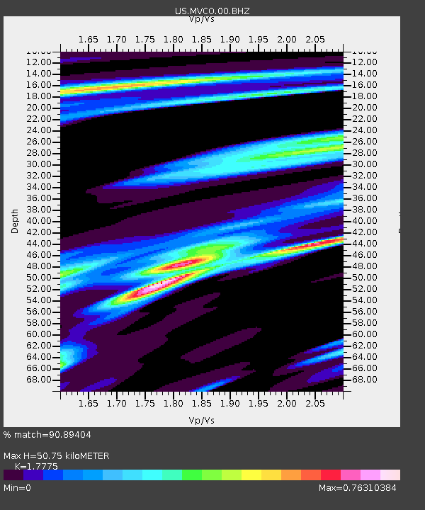
| Estimated Moho Depth: |
50.75 km |
| Estimated Crust Vp/Vs: |
1.78 |
| Assumed Crust Vp: |
6.476 km/s |
| Estimated Crust Vs: |
3.643 km/s |
| Estimated Crust Poisson's Ratio: |
0.27 |
|
| Radial Match: |
90.89404 % |
| Radial Bump: |
323 |
| Transverse Match: |
82.90777 % |
| Transverse Bump: |
400 |
| SOD ConfigId: |
558545 |
| Insert Time: |
2013-09-17 16:11:54.863 +0000 |
| GWidth: |
2.5 |
| Max Bumps: |
400 |
| Tol: |
0.001 |
|
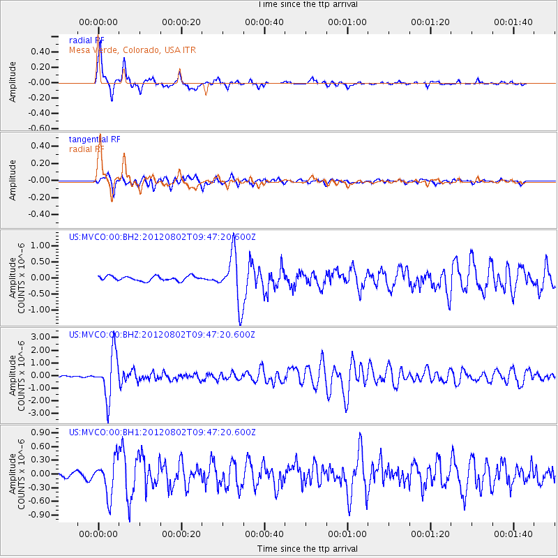
Signal To Noise
| Channel | StoN | STA | LTA |
| US:MVCO:00:BHZ:20120802T09:47:20.600Z | 43.054127 | 1.8077067E-6 | 4.198684E-8 |
| US:MVCO:00:BH1:20120802T09:47:20.600Z | 5.8525977 | 4.04298E-7 | 6.9080095E-8 |
| US:MVCO:00:BH2:20120802T09:47:20.600Z | 11.205425 | 8.040829E-7 | 7.175836E-8 |
| Arrivals |
| Ps | 6.4 SECOND |
| PpPs | 21 SECOND |
| PsPs/PpSs | 27 SECOND |


