You are here: Home > Network List > II - Global Seismograph Network (GSN - IRIS/IDA) Stations List
> Station WRAB Tennant Creek, NT, Australia > Earthquake Result Viewer
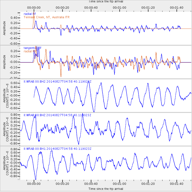
WRAB Tennant Creek, NT, Australia - Earthquake Result Viewer
*The percent match for this event was below the threshold and hence no stack was calculated.
| Earthquake location: |
Hokkaido, Japan Region |
| Earthquake latitude/longitude: |
41.1/143.2 |
| Earthquake time(UTC): |
2014/08/27 (239) 04:48:58 GMT |
| Earthquake Depth: |
26 km |
| Earthquake Magnitude: |
5.4 MW, 5.4 mb, 5.4 Mwb, 5.4 Mwc |
| Earthquake Catalog/Contributor: |
ISC/ISC |
|
| Network: |
II Global Seismograph Network (GSN - IRIS/IDA) |
| Station: |
WRAB Tennant Creek, NT, Australia |
| Lat/Lon: |
19.93 S/134.36 E |
| Elevation: |
366 m |
|
| Distance: |
61.2 deg |
| Az: |
189.457 deg |
| Baz: |
7.588 deg |
| Ray Param: |
$rayparam |
*The percent match for this event was below the threshold and hence was not used in the summary stack. |
|
| Radial Match: |
66.6483 % |
| Radial Bump: |
400 |
| Transverse Match: |
52.549866 % |
| Transverse Bump: |
376 |
| SOD ConfigId: |
3390531 |
| Insert Time: |
2019-04-13 15:44:39.001 +0000 |
| GWidth: |
2.5 |
| Max Bumps: |
400 |
| Tol: |
0.001 |
|
Signal To Noise
| Channel | StoN | STA | LTA |
| II:WRAB:00:BHZ:20140827T04:58:40.119023Z | 2.3573236 | 5.20723E-7 | 2.2089584E-7 |
| II:WRAB:00:BH1:20140827T04:58:40.119023Z | 4.3755784 | 5.516308E-7 | 1.2607038E-7 |
| II:WRAB:00:BH2:20140827T04:58:40.119023Z | 1.1649045 | 3.1866836E-7 | 2.7355748E-7 |
| Arrivals |
| Ps | |
| PpPs | |
| PsPs/PpSs | |


