You are here: Home > Network List > US - United States National Seismic Network Stations List
> Station WUAZ Wupatki, Arizona, USA > Earthquake Result Viewer
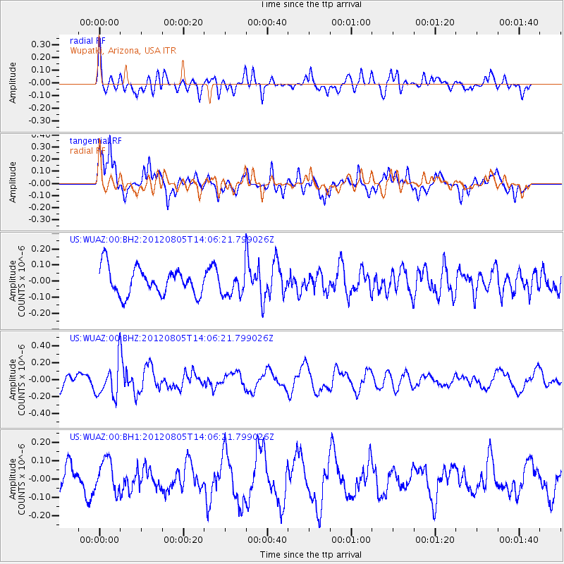
WUAZ Wupatki, Arizona, USA - Earthquake Result Viewer
*The percent match for this event was below the threshold and hence no stack was calculated.
| Earthquake location: |
Fiji Islands Region |
| Earthquake latitude/longitude: |
-21.1/-178.4 |
| Earthquake time(UTC): |
2012/08/05 (218) 13:55:10 GMT |
| Earthquake Depth: |
484 km |
| Earthquake Magnitude: |
5.5 MB, 5.8 MW, 5.9 MW |
| Earthquake Catalog/Contributor: |
WHDF/NEIC |
|
| Network: |
US United States National Seismic Network |
| Station: |
WUAZ Wupatki, Arizona, USA |
| Lat/Lon: |
35.52 N/111.37 W |
| Elevation: |
1592 m |
|
| Distance: |
84.8 deg |
| Az: |
48.931 deg |
| Baz: |
239.617 deg |
| Ray Param: |
$rayparam |
*The percent match for this event was below the threshold and hence was not used in the summary stack. |
|
| Radial Match: |
66.934265 % |
| Radial Bump: |
400 |
| Transverse Match: |
75.6366 % |
| Transverse Bump: |
400 |
| SOD ConfigId: |
558545 |
| Insert Time: |
2013-09-17 16:21:28.202 +0000 |
| GWidth: |
2.5 |
| Max Bumps: |
400 |
| Tol: |
0.001 |
|
Signal To Noise
| Channel | StoN | STA | LTA |
| US:WUAZ:00:BHZ:20120805T14:06:21.799026Z | 2.192856 | 2.0192415E-7 | 9.208272E-8 |
| US:WUAZ:00:BH1:20120805T14:06:21.799026Z | 1.1586895 | 8.936117E-8 | 7.712262E-8 |
| US:WUAZ:00:BH2:20120805T14:06:21.799026Z | 0.9191352 | 7.652254E-8 | 8.325493E-8 |
| Arrivals |
| Ps | |
| PpPs | |
| PsPs/PpSs | |


