You are here: Home > Network List > US - United States National Seismic Network Stations List
> Station HAWA Hanford, Washington, USA > Earthquake Result Viewer
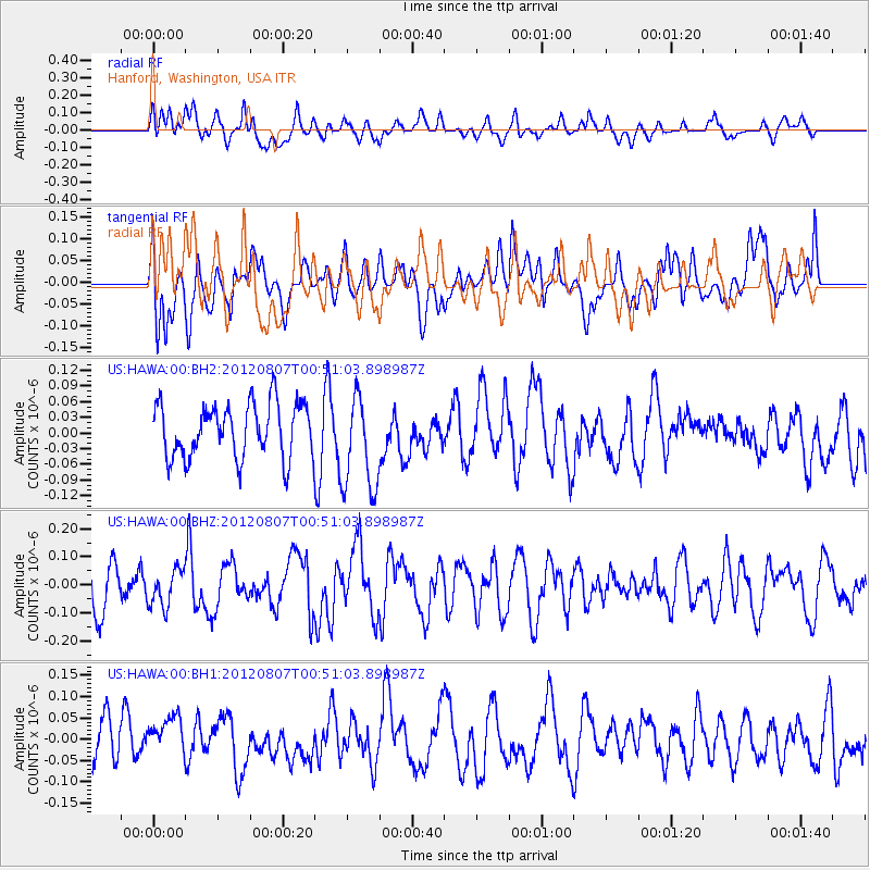
HAWA Hanford, Washington, USA - Earthquake Result Viewer
*The percent match for this event was below the threshold and hence no stack was calculated.
| Earthquake location: |
Near Coast Of Northern Chile |
| Earthquake latitude/longitude: |
-27.8/-70.8 |
| Earthquake time(UTC): |
2012/08/07 (220) 00:39:02 GMT |
| Earthquake Depth: |
68 km |
| Earthquake Magnitude: |
5.6 ML |
| Earthquake Catalog/Contributor: |
NEIC PDE/NEIC PDE-W |
|
| Network: |
US United States National Seismic Network |
| Station: |
HAWA Hanford, Washington, USA |
| Lat/Lon: |
46.39 N/119.53 W |
| Elevation: |
364 m |
|
| Distance: |
86.0 deg |
| Az: |
328.568 deg |
| Baz: |
138.131 deg |
| Ray Param: |
$rayparam |
*The percent match for this event was below the threshold and hence was not used in the summary stack. |
|
| Radial Match: |
51.02565 % |
| Radial Bump: |
400 |
| Transverse Match: |
48.756794 % |
| Transverse Bump: |
400 |
| SOD ConfigId: |
558545 |
| Insert Time: |
2013-09-17 16:24:21.778 +0000 |
| GWidth: |
2.5 |
| Max Bumps: |
400 |
| Tol: |
0.001 |
|
Signal To Noise
| Channel | StoN | STA | LTA |
| US:HAWA:00:BHZ:20120807T00:51:03.898987Z | 0.80037445 | 6.4996286E-8 | 8.120734E-8 |
| US:HAWA:00:BH1:20120807T00:51:03.898987Z | 0.8660056 | 5.446244E-8 | 6.288925E-8 |
| US:HAWA:00:BH2:20120807T00:51:03.898987Z | 1.8164607 | 9.368254E-8 | 5.1574215E-8 |
| Arrivals |
| Ps | |
| PpPs | |
| PsPs/PpSs | |


