You are here: Home > Network List > IU - Global Seismograph Network (GSN - IRIS/USGS) Stations List
> Station RSSD Black Hills, South Dakota, USA > Earthquake Result Viewer
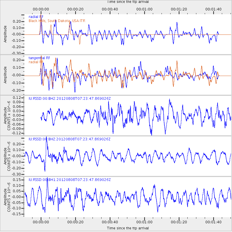
RSSD Black Hills, South Dakota, USA - Earthquake Result Viewer
*The percent match for this event was below the threshold and hence no stack was calculated.
| Earthquake location: |
Northeast Of Taiwan |
| Earthquake latitude/longitude: |
25.9/124.9 |
| Earthquake time(UTC): |
2012/08/08 (221) 07:11:01 GMT |
| Earthquake Depth: |
133 km |
| Earthquake Magnitude: |
5.5 MB, 5.4 MW, 5.4 MW |
| Earthquake Catalog/Contributor: |
WHDF/NEIC |
|
| Network: |
IU Global Seismograph Network (GSN - IRIS/USGS) |
| Station: |
RSSD Black Hills, South Dakota, USA |
| Lat/Lon: |
44.12 N/104.04 W |
| Elevation: |
2090 m |
|
| Distance: |
97.2 deg |
| Az: |
33.194 deg |
| Baz: |
316.776 deg |
| Ray Param: |
$rayparam |
*The percent match for this event was below the threshold and hence was not used in the summary stack. |
|
| Radial Match: |
52.245865 % |
| Radial Bump: |
400 |
| Transverse Match: |
57.165855 % |
| Transverse Bump: |
400 |
| SOD ConfigId: |
558545 |
| Insert Time: |
2013-09-17 16:27:31.240 +0000 |
| GWidth: |
2.5 |
| Max Bumps: |
400 |
| Tol: |
0.001 |
|
Signal To Noise
| Channel | StoN | STA | LTA |
| IU:RSSD:00:BHZ:20120808T07:23:47.869026Z | 2.3999908 | 1.2922737E-7 | 5.3844946E-8 |
| IU:RSSD:00:BH1:20120808T07:23:47.869026Z | 1.5152915 | 8.352454E-8 | 5.512111E-8 |
| IU:RSSD:00:BH2:20120808T07:23:47.869026Z | 1.4147211 | 3.541059E-8 | 2.5030083E-8 |
| Arrivals |
| Ps | |
| PpPs | |
| PsPs/PpSs | |


