You are here: Home > Network List > US - United States National Seismic Network Stations List
> Station EGMT Eagleton, Montana, USA > Earthquake Result Viewer
EGMT Eagleton, Montana, USA - Earthquake Result Viewer
*The percent match for this event was below the threshold and hence no stack was calculated.
| Earthquake location: |
Northeast Of Taiwan |
| Earthquake latitude/longitude: |
25.9/124.9 |
| Earthquake time(UTC): |
2012/08/08 (221) 07:11:01 GMT |
| Earthquake Depth: |
133 km |
| Earthquake Magnitude: |
5.5 MB, 5.4 MW, 5.4 MW |
| Earthquake Catalog/Contributor: |
WHDF/NEIC |
|
| Network: |
US United States National Seismic Network |
| Station: |
EGMT Eagleton, Montana, USA |
| Lat/Lon: |
48.02 N/109.75 W |
| Elevation: |
1055 m |
|
| Distance: |
91.6 deg |
| Az: |
33.225 deg |
| Baz: |
312.665 deg |
| Ray Param: |
$rayparam |
*The percent match for this event was below the threshold and hence was not used in the summary stack. |
|
| Radial Match: |
42.571194 % |
| Radial Bump: |
400 |
| Transverse Match: |
48.086746 % |
| Transverse Bump: |
400 |
| SOD ConfigId: |
558545 |
| Insert Time: |
2013-09-17 16:28:15.059 +0000 |
| GWidth: |
2.5 |
| Max Bumps: |
400 |
| Tol: |
0.001 |
|
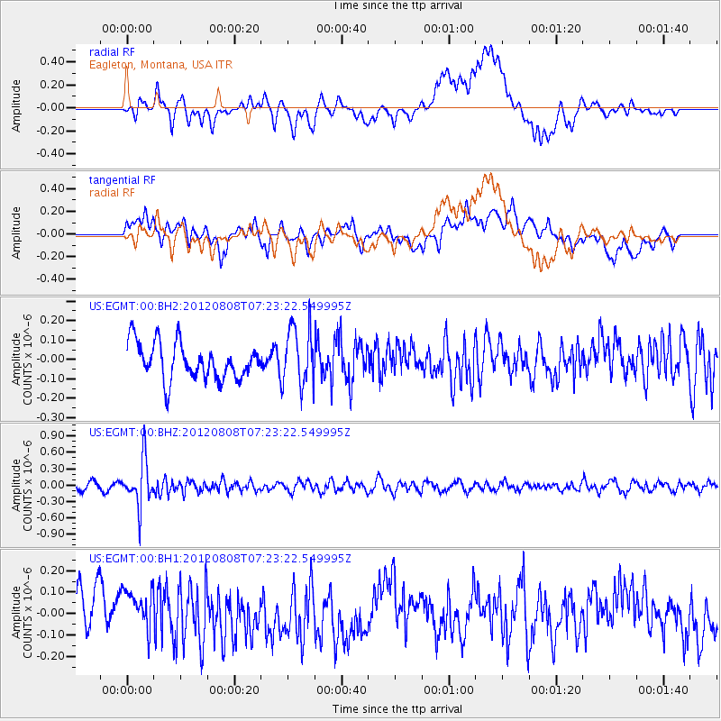
Signal To Noise
| Channel | StoN | STA | LTA |
| US:EGMT:00:BHZ:20120808T07:23:22.549995Z | 7.043463 | 4.1953882E-7 | 5.9564282E-8 |
| US:EGMT:00:BH1:20120808T07:23:22.549995Z | 0.94663143 | 1.2427871E-7 | 1.3128522E-7 |
| US:EGMT:00:BH2:20120808T07:23:22.549995Z | 1.6037296 | 1.5126014E-7 | 9.431773E-8 |
| Arrivals |
| Ps | |
| PpPs | |
| PsPs/PpSs | |


