You are here: Home > Network List > IU - Global Seismograph Network (GSN - IRIS/USGS) Stations List
> Station RSSD Black Hills, South Dakota, USA > Earthquake Result Viewer
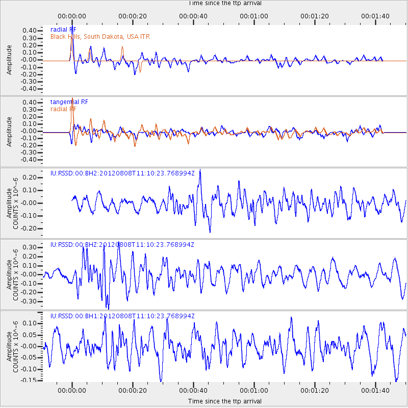
RSSD Black Hills, South Dakota, USA - Earthquake Result Viewer
*The percent match for this event was below the threshold and hence no stack was calculated.
| Earthquake location: |
Fiji Islands |
| Earthquake latitude/longitude: |
-16.0/178.1 |
| Earthquake time(UTC): |
2012/08/08 (221) 10:57:44 GMT |
| Earthquake Depth: |
13 km |
| Earthquake Magnitude: |
5.9 MW, 5.5 MS, 5.6 MB, 5.9 MW |
| Earthquake Catalog/Contributor: |
NEIC PDE/NEIC PDE-W |
|
| Network: |
IU Global Seismograph Network (GSN - IRIS/USGS) |
| Station: |
RSSD Black Hills, South Dakota, USA |
| Lat/Lon: |
44.12 N/104.04 W |
| Elevation: |
2090 m |
|
| Distance: |
92.6 deg |
| Az: |
44.823 deg |
| Baz: |
250.263 deg |
| Ray Param: |
$rayparam |
*The percent match for this event was below the threshold and hence was not used in the summary stack. |
|
| Radial Match: |
68.98975 % |
| Radial Bump: |
400 |
| Transverse Match: |
49.679123 % |
| Transverse Bump: |
400 |
| SOD ConfigId: |
558545 |
| Insert Time: |
2013-09-17 16:30:23.093 +0000 |
| GWidth: |
2.5 |
| Max Bumps: |
400 |
| Tol: |
0.001 |
|
Signal To Noise
| Channel | StoN | STA | LTA |
| IU:RSSD:00:BHZ:20120808T11:10:23.768994Z | 3.7276187 | 1.3986293E-7 | 3.752072E-8 |
| IU:RSSD:00:BH1:20120808T11:10:23.768994Z | 0.70012665 | 3.0701234E-8 | 4.385097E-8 |
| IU:RSSD:00:BH2:20120808T11:10:23.768994Z | 1.2000723 | 5.2386852E-8 | 4.365308E-8 |
| Arrivals |
| Ps | |
| PpPs | |
| PsPs/PpSs | |


