You are here: Home > Network List > US - United States National Seismic Network Stations List
> Station AMTX Amarillo, Texas, USA > Earthquake Result Viewer
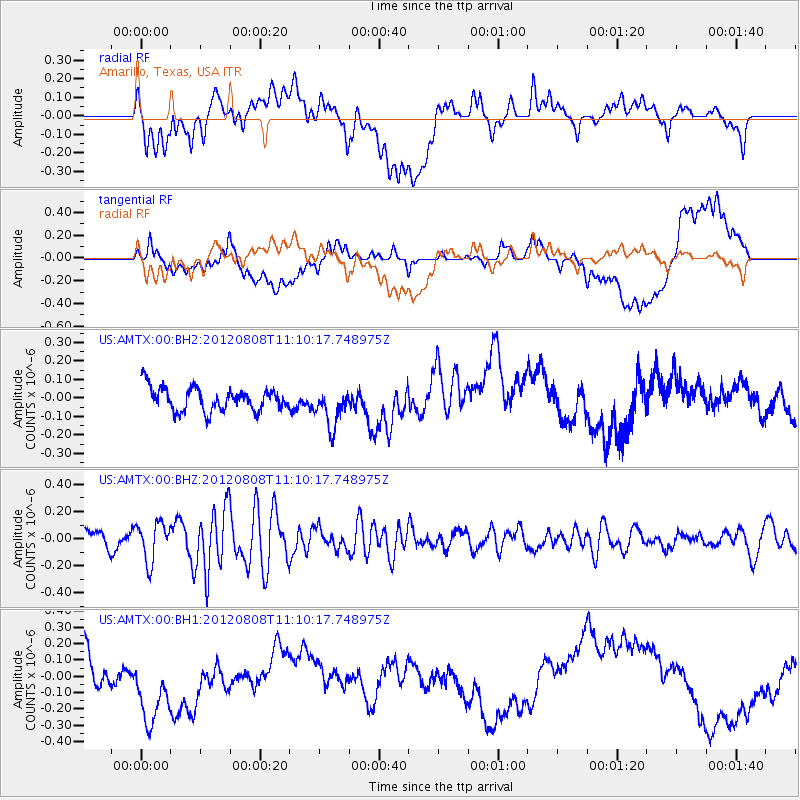
AMTX Amarillo, Texas, USA - Earthquake Result Viewer
*The percent match for this event was below the threshold and hence no stack was calculated.
| Earthquake location: |
Fiji Islands |
| Earthquake latitude/longitude: |
-16.0/178.1 |
| Earthquake time(UTC): |
2012/08/08 (221) 10:57:44 GMT |
| Earthquake Depth: |
13 km |
| Earthquake Magnitude: |
5.9 MW, 5.5 MS, 5.6 MB, 5.9 MW |
| Earthquake Catalog/Contributor: |
NEIC PDE/NEIC PDE-W |
|
| Network: |
US United States National Seismic Network |
| Station: |
AMTX Amarillo, Texas, USA |
| Lat/Lon: |
34.53 N/101.41 W |
| Elevation: |
1010 m |
|
| Distance: |
91.4 deg |
| Az: |
54.546 deg |
| Baz: |
251.59 deg |
| Ray Param: |
$rayparam |
*The percent match for this event was below the threshold and hence was not used in the summary stack. |
|
| Radial Match: |
38.618336 % |
| Radial Bump: |
400 |
| Transverse Match: |
20.650524 % |
| Transverse Bump: |
400 |
| SOD ConfigId: |
558545 |
| Insert Time: |
2013-09-17 16:30:41.768 +0000 |
| GWidth: |
2.5 |
| Max Bumps: |
400 |
| Tol: |
0.001 |
|
Signal To Noise
| Channel | StoN | STA | LTA |
| US:AMTX:00:BHZ:20120808T11:10:17.748975Z | 1.78941 | 1.428053E-7 | 7.98058E-8 |
| US:AMTX:00:BH1:20120808T11:10:17.748975Z | 2.4756403 | 2.9400226E-7 | 1.18758074E-7 |
| US:AMTX:00:BH2:20120808T11:10:17.748975Z | 1.6523523 | 9.97336E-8 | 6.035855E-8 |
| Arrivals |
| Ps | |
| PpPs | |
| PsPs/PpSs | |


