You are here: Home > Network List > US - United States National Seismic Network Stations List
> Station CBKS Cedar Bluff, Kansas, USA > Earthquake Result Viewer
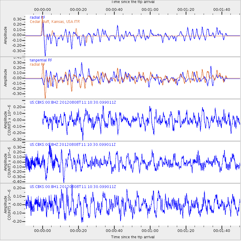
CBKS Cedar Bluff, Kansas, USA - Earthquake Result Viewer
*The percent match for this event was below the threshold and hence no stack was calculated.
| Earthquake location: |
Fiji Islands |
| Earthquake latitude/longitude: |
-16.0/178.1 |
| Earthquake time(UTC): |
2012/08/08 (221) 10:57:44 GMT |
| Earthquake Depth: |
13 km |
| Earthquake Magnitude: |
5.9 MW, 5.5 MS, 5.6 MB, 5.9 MW |
| Earthquake Catalog/Contributor: |
NEIC PDE/NEIC PDE-W |
|
| Network: |
US United States National Seismic Network |
| Station: |
CBKS Cedar Bluff, Kansas, USA |
| Lat/Lon: |
38.81 N/99.74 W |
| Elevation: |
677 m |
|
| Distance: |
94.0 deg |
| Az: |
50.884 deg |
| Baz: |
252.756 deg |
| Ray Param: |
$rayparam |
*The percent match for this event was below the threshold and hence was not used in the summary stack. |
|
| Radial Match: |
60.72509 % |
| Radial Bump: |
400 |
| Transverse Match: |
55.20881 % |
| Transverse Bump: |
400 |
| SOD ConfigId: |
558545 |
| Insert Time: |
2013-09-17 16:30:47.905 +0000 |
| GWidth: |
2.5 |
| Max Bumps: |
400 |
| Tol: |
0.001 |
|
Signal To Noise
| Channel | StoN | STA | LTA |
| US:CBKS:00:BHZ:20120808T11:10:30.099011Z | 3.2830956 | 1.8118175E-7 | 5.5186252E-8 |
| US:CBKS:00:BH1:20120808T11:10:30.099011Z | 0.82347083 | 5.629633E-8 | 6.836469E-8 |
| US:CBKS:00:BH2:20120808T11:10:30.099011Z | 1.1006966 | 8.91918E-8 | 8.103214E-8 |
| Arrivals |
| Ps | |
| PpPs | |
| PsPs/PpSs | |


