You are here: Home > Network List > TA - USArray Transportable Network (new EarthScope stations) Stations List
> Station H63A New Sharon, ME, USA > Earthquake Result Viewer
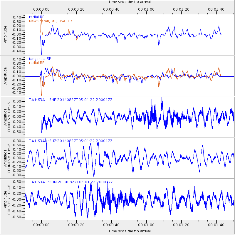
H63A New Sharon, ME, USA - Earthquake Result Viewer
*The percent match for this event was below the threshold and hence no stack was calculated.
| Earthquake location: |
Hokkaido, Japan Region |
| Earthquake latitude/longitude: |
41.1/143.2 |
| Earthquake time(UTC): |
2014/08/27 (239) 04:48:58 GMT |
| Earthquake Depth: |
26 km |
| Earthquake Magnitude: |
5.4 MW, 5.4 mb, 5.4 Mwb, 5.4 Mwc |
| Earthquake Catalog/Contributor: |
ISC/ISC |
|
| Network: |
TA USArray Transportable Network (new EarthScope stations) |
| Station: |
H63A New Sharon, ME, USA |
| Lat/Lon: |
44.66 N/70.04 W |
| Elevation: |
109 m |
|
| Distance: |
89.6 deg |
| Az: |
23.004 deg |
| Baz: |
335.541 deg |
| Ray Param: |
$rayparam |
*The percent match for this event was below the threshold and hence was not used in the summary stack. |
|
| Radial Match: |
58.79451 % |
| Radial Bump: |
400 |
| Transverse Match: |
50.73352 % |
| Transverse Bump: |
400 |
| SOD ConfigId: |
3390531 |
| Insert Time: |
2019-04-13 15:48:16.894 +0000 |
| GWidth: |
2.5 |
| Max Bumps: |
400 |
| Tol: |
0.001 |
|
Signal To Noise
| Channel | StoN | STA | LTA |
| TA:H63A: :BHZ:20140827T05:01:22.200017Z | 2.064387 | 4.5018857E-7 | 2.1807371E-7 |
| TA:H63A: :BHN:20140827T05:01:22.200017Z | 0.42353806 | 1.0071789E-7 | 2.3780127E-7 |
| TA:H63A: :BHE:20140827T05:01:22.200017Z | 1.269661 | 2.2541383E-7 | 1.775386E-7 |
| Arrivals |
| Ps | |
| PpPs | |
| PsPs/PpSs | |


