You are here: Home > Network List > US - United States National Seismic Network Stations List
> Station DGMT Dagmar, Montana, USA > Earthquake Result Viewer
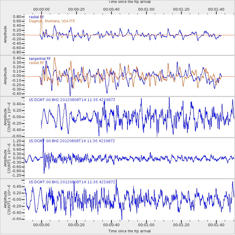
DGMT Dagmar, Montana, USA - Earthquake Result Viewer
*The percent match for this event was below the threshold and hence no stack was calculated.
| Earthquake location: |
Alaska Peninsula |
| Earthquake latitude/longitude: |
54.9/-161.2 |
| Earthquake time(UTC): |
2012/08/08 (221) 14:05:17 GMT |
| Earthquake Depth: |
43 km |
| Earthquake Magnitude: |
5.6 MB, 5.2 MW, 5.1 MW |
| Earthquake Catalog/Contributor: |
WHDF/NEIC |
|
| Network: |
US United States National Seismic Network |
| Station: |
DGMT Dagmar, Montana, USA |
| Lat/Lon: |
48.47 N/104.20 W |
| Elevation: |
0.0 m |
|
| Distance: |
35.1 deg |
| Az: |
76.343 deg |
| Baz: |
302.461 deg |
| Ray Param: |
$rayparam |
*The percent match for this event was below the threshold and hence was not used in the summary stack. |
|
| Radial Match: |
51.94713 % |
| Radial Bump: |
400 |
| Transverse Match: |
54.206997 % |
| Transverse Bump: |
400 |
| SOD ConfigId: |
558545 |
| Insert Time: |
2013-09-17 16:35:24.932 +0000 |
| GWidth: |
2.5 |
| Max Bumps: |
400 |
| Tol: |
0.001 |
|
Signal To Noise
| Channel | StoN | STA | LTA |
| US:DGMT:00:BHZ:20120808T14:11:36.423987Z | 4.1976933 | 4.363871E-7 | 1.0395879E-7 |
| US:DGMT:00:BH1:20120808T14:11:36.423987Z | 1.6068996 | 2.3463267E-7 | 1.4601575E-7 |
| US:DGMT:00:BH2:20120808T14:11:36.423987Z | 0.99442685 | 1.9340953E-7 | 1.9449348E-7 |
| Arrivals |
| Ps | |
| PpPs | |
| PsPs/PpSs | |


