You are here: Home > Network List > US - United States National Seismic Network Stations List
> Station DUG Dugway, Tooele County, Utah, USA > Earthquake Result Viewer
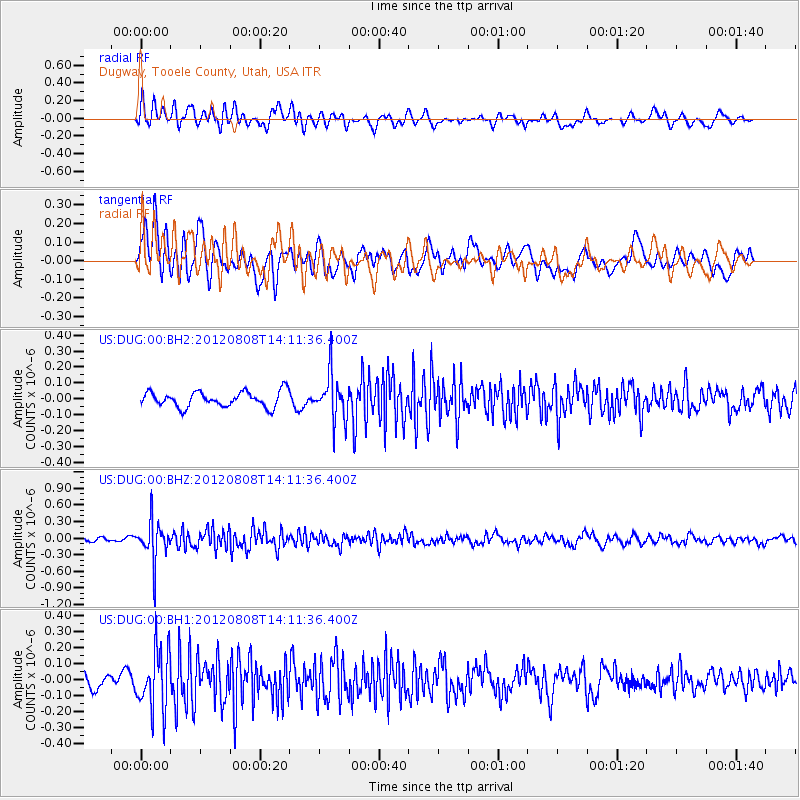
DUG Dugway, Tooele County, Utah, USA - Earthquake Result Viewer
*The percent match for this event was below the threshold and hence no stack was calculated.
| Earthquake location: |
Alaska Peninsula |
| Earthquake latitude/longitude: |
54.9/-161.2 |
| Earthquake time(UTC): |
2012/08/08 (221) 14:05:17 GMT |
| Earthquake Depth: |
43 km |
| Earthquake Magnitude: |
5.6 MB, 5.2 MW, 5.1 MW |
| Earthquake Catalog/Contributor: |
WHDF/NEIC |
|
| Network: |
US United States National Seismic Network |
| Station: |
DUG Dugway, Tooele County, Utah, USA |
| Lat/Lon: |
40.19 N/112.81 W |
| Elevation: |
1477 m |
|
| Distance: |
35.1 deg |
| Az: |
94.349 deg |
| Baz: |
311.216 deg |
| Ray Param: |
$rayparam |
*The percent match for this event was below the threshold and hence was not used in the summary stack. |
|
| Radial Match: |
63.670277 % |
| Radial Bump: |
400 |
| Transverse Match: |
65.1289 % |
| Transverse Bump: |
400 |
| SOD ConfigId: |
558545 |
| Insert Time: |
2013-09-17 16:35:31.543 +0000 |
| GWidth: |
2.5 |
| Max Bumps: |
400 |
| Tol: |
0.001 |
|
Signal To Noise
| Channel | StoN | STA | LTA |
| US:DUG:00:BHZ:20120808T14:11:36.400Z | 7.284956 | 3.686653E-7 | 5.060639E-8 |
| US:DUG:00:BH1:20120808T14:11:36.400Z | 3.8111992 | 1.9076393E-7 | 5.0053515E-8 |
| US:DUG:00:BH2:20120808T14:11:36.400Z | 2.897818 | 1.4088491E-7 | 4.8617583E-8 |
| Arrivals |
| Ps | |
| PpPs | |
| PsPs/PpSs | |


