You are here: Home > Network List > US - United States National Seismic Network Stations List
> Station ERPA Erie, Pennsylvania, USA > Earthquake Result Viewer
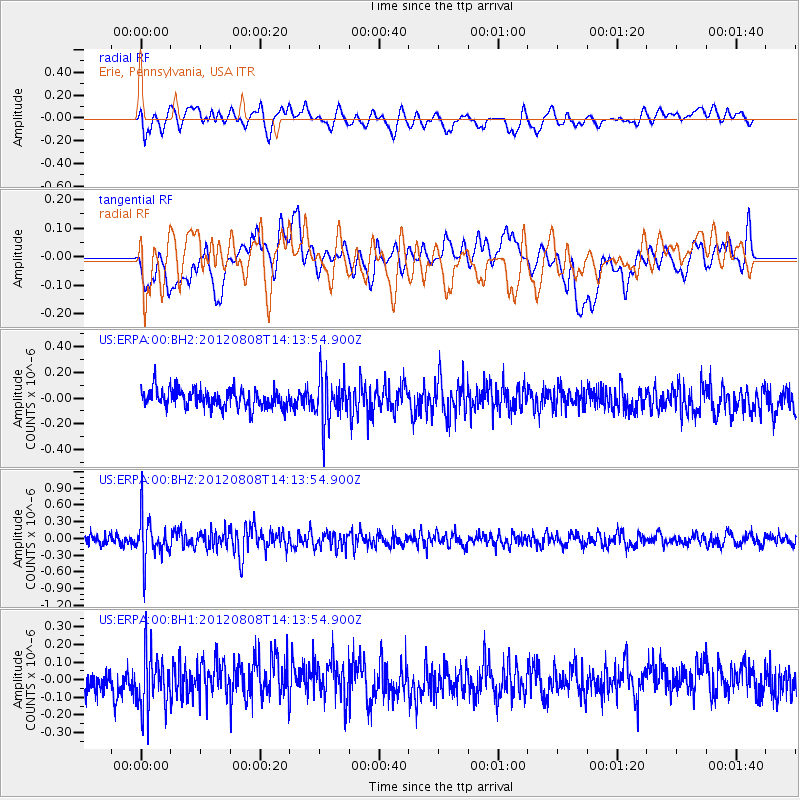
ERPA Erie, Pennsylvania, USA - Earthquake Result Viewer
*The percent match for this event was below the threshold and hence no stack was calculated.
| Earthquake location: |
Alaska Peninsula |
| Earthquake latitude/longitude: |
54.9/-161.2 |
| Earthquake time(UTC): |
2012/08/08 (221) 14:05:17 GMT |
| Earthquake Depth: |
43 km |
| Earthquake Magnitude: |
5.6 MB, 5.2 MW, 5.1 MW |
| Earthquake Catalog/Contributor: |
WHDF/NEIC |
|
| Network: |
US United States National Seismic Network |
| Station: |
ERPA Erie, Pennsylvania, USA |
| Lat/Lon: |
42.12 N/79.99 W |
| Elevation: |
306 m |
|
| Distance: |
52.3 deg |
| Az: |
68.242 deg |
| Baz: |
313.834 deg |
| Ray Param: |
$rayparam |
*The percent match for this event was below the threshold and hence was not used in the summary stack. |
|
| Radial Match: |
50.089645 % |
| Radial Bump: |
400 |
| Transverse Match: |
45.502308 % |
| Transverse Bump: |
400 |
| SOD ConfigId: |
558545 |
| Insert Time: |
2013-09-17 16:35:39.841 +0000 |
| GWidth: |
2.5 |
| Max Bumps: |
400 |
| Tol: |
0.001 |
|
Signal To Noise
| Channel | StoN | STA | LTA |
| US:ERPA:00:BHZ:20120808T14:13:54.900Z | 4.5946994 | 3.890996E-7 | 8.4684444E-8 |
| US:ERPA:00:BH1:20120808T14:13:54.900Z | 2.029087 | 1.5925282E-7 | 7.8484966E-8 |
| US:ERPA:00:BH2:20120808T14:13:54.900Z | 2.476732 | 1.778746E-7 | 7.181827E-8 |
| Arrivals |
| Ps | |
| PpPs | |
| PsPs/PpSs | |


