You are here: Home > Network List > TJ - Tajikistan National Seismic Network Stations List
> Station GARM Garm, Tajikistan > Earthquake Result Viewer
GARM Garm, Tajikistan - Earthquake Result Viewer

| Earthquake location: |
Hokkaido, Japan Region |
| Earthquake latitude/longitude: |
41.1/143.2 |
| Earthquake time(UTC): |
2014/08/27 (239) 04:48:58 GMT |
| Earthquake Depth: |
26 km |
| Earthquake Magnitude: |
5.4 MW, 5.4 mb, 5.4 Mwb, 5.4 Mwc |
| Earthquake Catalog/Contributor: |
ISC/ISC |
|
| Network: |
TJ Tajikistan National Seismic Network |
| Station: |
GARM Garm, Tajikistan |
| Lat/Lon: |
39.00 N/70.32 E |
| Elevation: |
1305 m |
|
| Distance: |
54.3 deg |
| Az: |
293.486 deg |
| Baz: |
62.867 deg |
| Ray Param: |
0.06551137 |
| Estimated Moho Depth: |
57.5 km |
| Estimated Crust Vp/Vs: |
1.92 |
| Assumed Crust Vp: |
6.306 km/s |
| Estimated Crust Vs: |
3.28 km/s |
| Estimated Crust Poisson's Ratio: |
0.31 |
|
| Radial Match: |
86.82034 % |
| Radial Bump: |
400 |
| Transverse Match: |
81.300186 % |
| Transverse Bump: |
400 |
| SOD ConfigId: |
3390531 |
| Insert Time: |
2019-04-13 15:49:05.943 +0000 |
| GWidth: |
2.5 |
| Max Bumps: |
400 |
| Tol: |
0.001 |
|
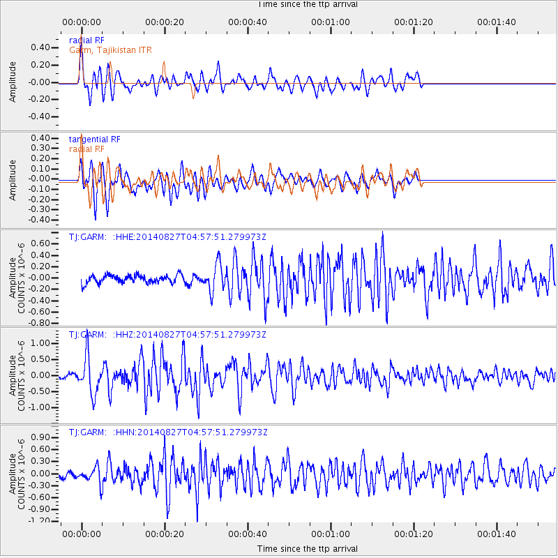
Signal To Noise
| Channel | StoN | STA | LTA |
| TJ:GARM: :HHZ:20140827T04:57:51.279973Z | 6.5358377 | 5.902826E-7 | 9.031476E-8 |
| TJ:GARM: :HHN:20140827T04:57:51.279973Z | 2.6528351 | 1.9009164E-7 | 7.165603E-8 |
| TJ:GARM: :HHE:20140827T04:57:51.279973Z | 3.505435 | 2.4052667E-7 | 6.861536E-8 |
| Arrivals |
| Ps | 8.8 SECOND |
| PpPs | 25 SECOND |
| PsPs/PpSs | 34 SECOND |


