You are here: Home > Network List > US - United States National Seismic Network Stations List
> Station WMOK Wichita Mountains, Oklahoma, USA > Earthquake Result Viewer
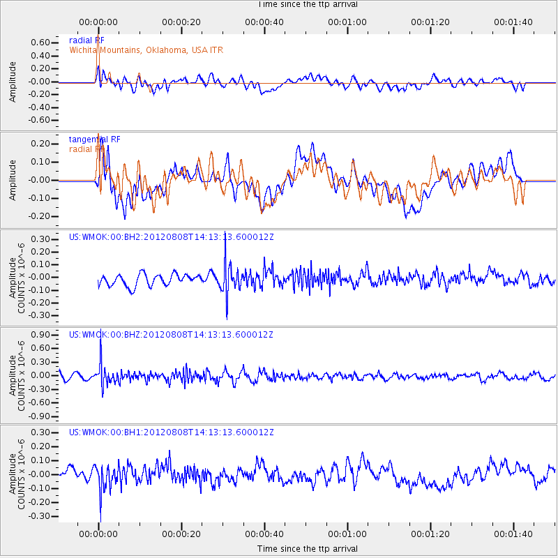
WMOK Wichita Mountains, Oklahoma, USA - Earthquake Result Viewer
*The percent match for this event was below the threshold and hence no stack was calculated.
| Earthquake location: |
Alaska Peninsula |
| Earthquake latitude/longitude: |
54.9/-161.2 |
| Earthquake time(UTC): |
2012/08/08 (221) 14:05:17 GMT |
| Earthquake Depth: |
43 km |
| Earthquake Magnitude: |
5.6 MB, 5.2 MW, 5.1 MW |
| Earthquake Catalog/Contributor: |
WHDF/NEIC |
|
| Network: |
US United States National Seismic Network |
| Station: |
WMOK Wichita Mountains, Oklahoma, USA |
| Lat/Lon: |
34.74 N/98.78 W |
| Elevation: |
486 m |
|
| Distance: |
46.9 deg |
| Az: |
88.687 deg |
| Baz: |
315.454 deg |
| Ray Param: |
$rayparam |
*The percent match for this event was below the threshold and hence was not used in the summary stack. |
|
| Radial Match: |
49.692547 % |
| Radial Bump: |
400 |
| Transverse Match: |
39.724094 % |
| Transverse Bump: |
400 |
| SOD ConfigId: |
558545 |
| Insert Time: |
2013-09-17 16:37:20.888 +0000 |
| GWidth: |
2.5 |
| Max Bumps: |
400 |
| Tol: |
0.001 |
|
Signal To Noise
| Channel | StoN | STA | LTA |
| US:WMOK:00:BHZ:20120808T14:13:13.600012Z | 4.240249 | 2.4777526E-7 | 5.843413E-8 |
| US:WMOK:00:BH1:20120808T14:13:13.600012Z | 2.0459254 | 8.8582816E-8 | 4.3297188E-8 |
| US:WMOK:00:BH2:20120808T14:13:13.600012Z | 2.6245022 | 1.1719701E-7 | 4.465495E-8 |
| Arrivals |
| Ps | |
| PpPs | |
| PsPs/PpSs | |


