You are here: Home > Network List > US - United States National Seismic Network Stations List
> Station ERPA Erie, Pennsylvania, USA > Earthquake Result Viewer
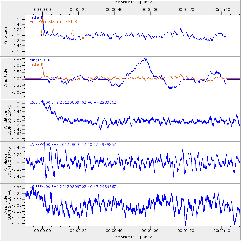
ERPA Erie, Pennsylvania, USA - Earthquake Result Viewer
*The percent match for this event was below the threshold and hence no stack was calculated.
| Earthquake location: |
Revilla Gigedo Islands Region |
| Earthquake latitude/longitude: |
19.9/-109.3 |
| Earthquake time(UTC): |
2012/08/09 (222) 02:34:41 GMT |
| Earthquake Depth: |
10 km |
| Earthquake Magnitude: |
5.6 MW, 5.0 MS, 5.1 MB, 5.5 MW |
| Earthquake Catalog/Contributor: |
WHDF/NEIC |
|
| Network: |
US United States National Seismic Network |
| Station: |
ERPA Erie, Pennsylvania, USA |
| Lat/Lon: |
42.12 N/79.99 W |
| Elevation: |
306 m |
|
| Distance: |
33.2 deg |
| Az: |
41.739 deg |
| Baz: |
237.329 deg |
| Ray Param: |
$rayparam |
*The percent match for this event was below the threshold and hence was not used in the summary stack. |
|
| Radial Match: |
58.694202 % |
| Radial Bump: |
400 |
| Transverse Match: |
41.925407 % |
| Transverse Bump: |
400 |
| SOD ConfigId: |
558545 |
| Insert Time: |
2013-09-17 16:40:14.279 +0000 |
| GWidth: |
2.5 |
| Max Bumps: |
400 |
| Tol: |
0.001 |
|
Signal To Noise
| Channel | StoN | STA | LTA |
| US:ERPA:00:BHZ:20120809T02:40:47.298986Z | 3.223209 | 2.6127827E-7 | 8.1061536E-8 |
| US:ERPA:00:BH1:20120809T02:40:47.298986Z | 0.68180895 | 2.7440578E-7 | 4.0246726E-7 |
| US:ERPA:00:BH2:20120809T02:40:47.298986Z | 1.2627796 | 3.2346338E-7 | 2.5615188E-7 |
| Arrivals |
| Ps | |
| PpPs | |
| PsPs/PpSs | |


