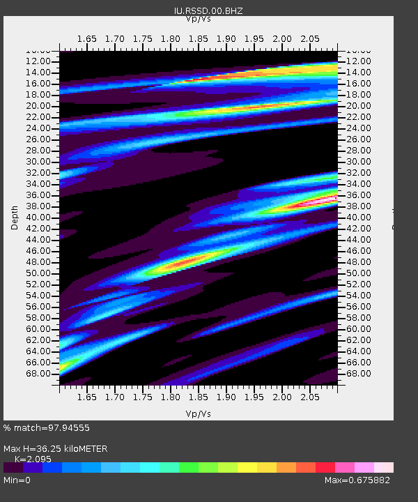
RSSD Black Hills, South Dakota, USA - Earthquake Result Viewer

Earthquake location: Fox Islands, Aleutian Islands
Earthquake latitude/longitude: 52.6/-167.4
Earthquake time(UTC): 2012/08/10 (223) 18:37:43 GMT
Earthquake Depth: 13 km
Earthquake Magnitude: 5.9 MB, 6.2 MS, 6.2 MW, 6.2 MW
Earthquake Catalog/Contributor: WHDF/NEIC
Network: IU Global Seismograph Network (GSN - IRIS/USGS)
Station: RSSD Black Hills, South Dakota, USA
Lat/Lon: 44.12 N/104.04 W
Elevation: 2090 m
Distance: 41.7 deg
Az: 75.455 deg
Baz: 304.999 deg
Ray Param: 0.07361968
Estimated Moho Depth: 36.25 km
Estimated Crust Vp/Vs: 2.10
Assumed Crust Vp: 6.242 km/s
Estimated Crust Vs: 2.979 km/s
Estimated Crust Poisson's Ratio: 0.35
Radial Match: 97.94555 %
Radial Bump: 275
Transverse Match: 85.86279 %
Transverse Bump: 400
SOD ConfigId: 558545
Insert Time: 2013-09-17 16:43:29.192 +0000
GWidth: 2.5
Max Bumps: 400
Tol: 0.001

Signal To Noise

ChannelStoNSTALTA
IU:RSSD:00:BHZ:20120810T18:45:00.569004Z5.43432663.2227558E-75.930368E-8
IU:RSSD:00:BH1:20120810T18:45:00.569004Z4.35684161.8282645E-74.1963073E-8
IU:RSSD:00:BH2:20120810T18:45:00.569004Z1.07514775.0010744E-84.651523E-8
Arrivals
Ps6.7 SECOND
PpPs17 SECOND
PsPs/PpSs24 SECOND