ERPA Erie, Pennsylvania, USA - Earthquake Result Viewer
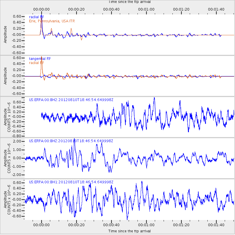
Earthquake location: Fox Islands, Aleutian Islands
Earthquake latitude/longitude: 52.6/-167.4
Earthquake time(UTC): 2012/08/10 (223) 18:37:43 GMT
Earthquake Depth: 13 km
Earthquake Magnitude: 5.9 MB, 6.2 MS, 6.2 MW, 6.2 MW
Earthquake Catalog/Contributor: WHDF/NEIC
Network: US United States National Seismic Network
Station: ERPA Erie, Pennsylvania, USA
Lat/Lon: 42.12 N/79.99 W
Elevation: 306 m
Distance: 56.6 deg
Az: 62.871 deg
Baz: 313.191 deg
Ray Param: 0.06400928
Estimated Moho Depth: 40.75 km
Estimated Crust Vp/Vs: 1.88
Assumed Crust Vp: 6.419 km/s
Estimated Crust Vs: 3.41 km/s
Estimated Crust Poisson's Ratio: 0.30
Radial Match: 94.19922 %
Radial Bump: 400
Transverse Match: 61.509953 %
Transverse Bump: 400
SOD ConfigId: 558545
Insert Time: 2013-09-17 16:45:06.445 +0000
GWidth: 2.5
Max Bumps: 400
Tol: 0.001

Signal To Noise

ChannelStoNSTALTA
US:ERPA:00:BHZ:20120810T18:46:54.649998Z4.2531514.9307766E-71.1593233E-7
US:ERPA:00:BH1:20120810T18:46:54.649998Z2.24707771.6331381E-77.267831E-8
US:ERPA:00:BH2:20120810T18:46:54.649998Z2.26578142.2154862E-79.778023E-8
Arrivals
Ps5.9 SECOND
PpPs17 SECOND
PsPs/PpSs23 SECOND