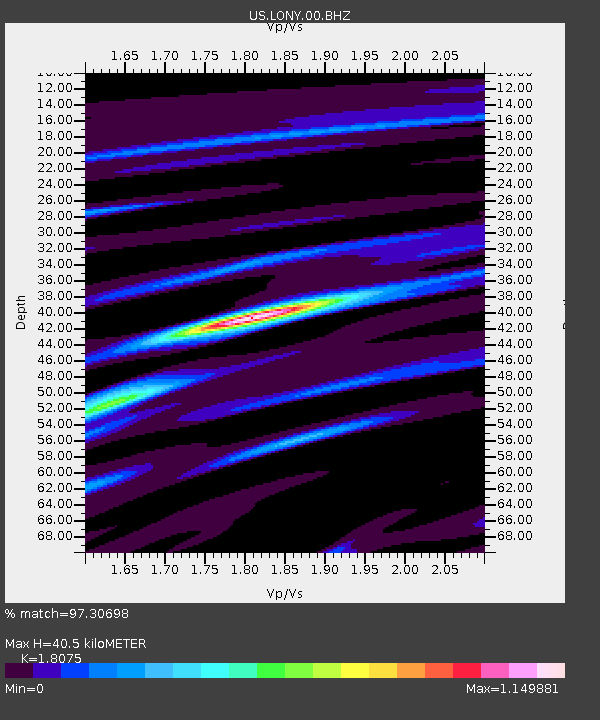
LONY Lake Ozonia, New York, USA - Earthquake Result Viewer
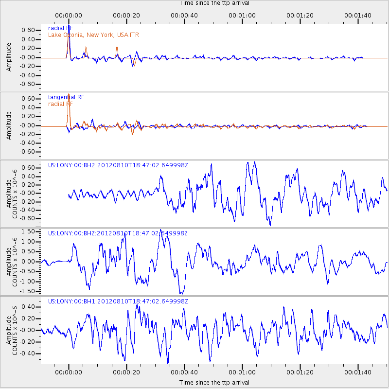
Earthquake location: Fox Islands, Aleutian Islands
Earthquake latitude/longitude: 52.6/-167.4
Earthquake time(UTC): 2012/08/10 (223) 18:37:43 GMT
Earthquake Depth: 13 km
Earthquake Magnitude: 5.9 MB, 6.2 MS, 6.2 MW, 6.2 MW
Earthquake Catalog/Contributor: WHDF/NEIC
Network: US United States National Seismic Network
Station: LONY Lake Ozonia, New York, USA
Lat/Lon: 44.62 N/74.58 W
Elevation: 440 m
Distance: 57.8 deg
Az: 57.484 deg
Baz: 313.972 deg
Ray Param: 0.063276164
Estimated Moho Depth: 40.5 km
Estimated Crust Vp/Vs: 1.81
Assumed Crust Vp: 6.419 km/s
Estimated Crust Vs: 3.551 km/s
Estimated Crust Poisson's Ratio: 0.28
Radial Match: 97.30698 %
Radial Bump: 330
Transverse Match: 82.78174 %
Transverse Bump: 400
SOD ConfigId: 558545
Insert Time: 2013-09-17 16:45:50.077 +0000
GWidth: 2.5
Max Bumps: 400
Tol: 0.001

Signal To Noise

ChannelStoNSTALTA
US:LONY:00:BHZ:20120810T18:47:02.649998Z6.61068254.3254965E-76.543192E-8
US:LONY:00:BH1:20120810T18:47:02.649998Z2.42752581.2451653E-75.12936E-8
US:LONY:00:BH2:20120810T18:47:02.649998Z3.2038892.1481759E-76.704901E-8
Arrivals
Ps5.3 SECOND
PpPs17 SECOND
PsPs/PpSs22 SECOND