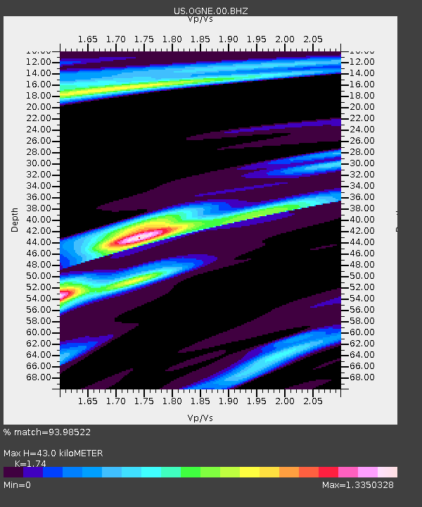
OGNE Ogallala, Nebraska, USA - Earthquake Result Viewer
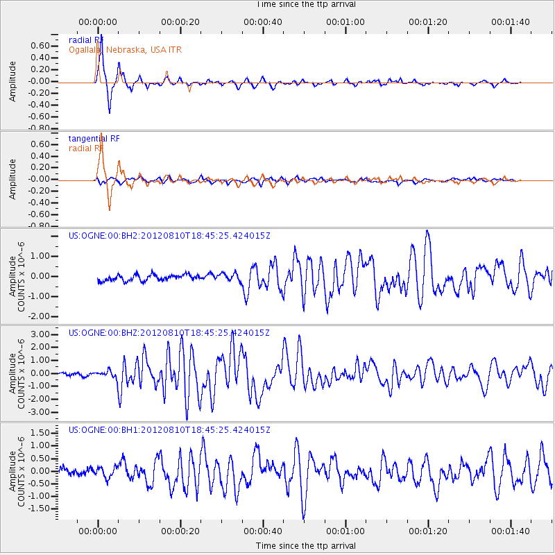
Earthquake location: Fox Islands, Aleutian Islands
Earthquake latitude/longitude: 52.6/-167.4
Earthquake time(UTC): 2012/08/10 (223) 18:37:43 GMT
Earthquake Depth: 13 km
Earthquake Magnitude: 5.9 MB, 6.2 MS, 6.2 MW, 6.2 MW
Earthquake Catalog/Contributor: WHDF/NEIC
Network: US United States National Seismic Network
Station: OGNE Ogallala, Nebraska, USA
Lat/Lon: 40.95 N/102.03 W
Elevation: 0.0 m
Distance: 44.8 deg
Az: 77.889 deg
Baz: 308.123 deg
Ray Param: 0.071699366
Estimated Moho Depth: 43.0 km
Estimated Crust Vp/Vs: 1.74
Assumed Crust Vp: 6.483 km/s
Estimated Crust Vs: 3.726 km/s
Estimated Crust Poisson's Ratio: 0.25
Radial Match: 93.98522 %
Radial Bump: 260
Transverse Match: 65.74245 %
Transverse Bump: 400
SOD ConfigId: 558545
Insert Time: 2013-09-17 16:46:19.810 +0000
GWidth: 2.5
Max Bumps: 400
Tol: 0.001

Signal To Noise

ChannelStoNSTALTA
US:OGNE:00:BHZ:20120810T18:45:25.424015Z2.91806722.9234022E-71.0018283E-7
US:OGNE:00:BH1:20120810T18:45:25.424015Z1.41021422.0819343E-71.4763249E-7
US:OGNE:00:BH2:20120810T18:45:25.424015Z1.32972061.9534032E-71.4690329E-7
Arrivals
Ps5.2 SECOND
PpPs17 SECOND
PsPs/PpSs22 SECOND