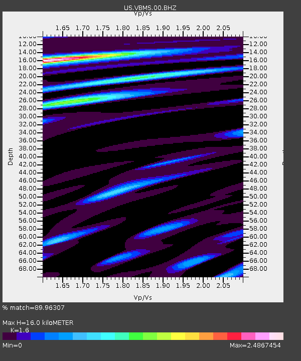
VBMS Vicksburg, Mississippi - Earthquake Result Viewer
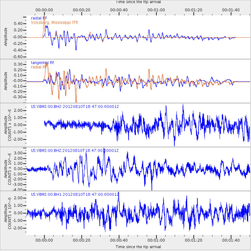
Earthquake location: Fox Islands, Aleutian Islands
Earthquake latitude/longitude: 52.6/-167.4
Earthquake time(UTC): 2012/08/10 (223) 18:37:43 GMT
Earthquake Depth: 13 km
Earthquake Magnitude: 5.9 MB, 6.2 MS, 6.2 MW, 6.2 MW
Earthquake Catalog/Contributor: WHDF/NEIC
Network: US United States National Seismic Network
Station: VBMS Vicksburg, Mississippi
Lat/Lon: 32.22 N/90.52 W
Elevation: 0.0 m
Distance: 57.5 deg
Az: 78.29 deg
Baz: 315.244 deg
Ray Param: 0.06346215
Estimated Moho Depth: 16.0 km
Estimated Crust Vp/Vs: 1.60
Assumed Crust Vp: 6.201 km/s
Estimated Crust Vs: 3.876 km/s
Estimated Crust Poisson's Ratio: 0.18
Radial Match: 89.96307 %
Radial Bump: 400
Transverse Match: 70.99989 %
Transverse Bump: 400
SOD ConfigId: 558545
Insert Time: 2013-09-17 16:46:42.559 +0000
GWidth: 2.5
Max Bumps: 400
Tol: 0.001

Signal To Noise

ChannelStoNSTALTA
US:VBMS:00:BHZ:20120810T18:47:00.60001Z3.16426256.549922E-72.069968E-7
US:VBMS:00:BH1:20120810T18:47:00.60001Z1.25452633.579402E-72.85319E-7
US:VBMS:00:BH2:20120810T18:47:00.60001Z1.29644753.8656808E-72.9817488E-7
Arrivals
Ps1.6 SECOND
PpPs6.4 SECOND
PsPs/PpSs8.0 SECOND