You are here: Home > Network List > II - Global Seismograph Network (GSN - IRIS/IDA) Stations List
> Station CMLA Cha de Macela, Sao Miguel Island, Azores > Earthquake Result Viewer
CMLA Cha de Macela, Sao Miguel Island, Azores - Earthquake Result Viewer
| Earthquake location: |
Armenia-Azerbaijan-Iran Bord Reg |
| Earthquake latitude/longitude: |
38.3/46.8 |
| Earthquake time(UTC): |
2012/08/11 (224) 12:23:18 GMT |
| Earthquake Depth: |
11 km |
| Earthquake Magnitude: |
6.4 MW, 6.2 MB, 6.4 MW, 6.7 MS |
| Earthquake Catalog/Contributor: |
NEIC PDE/NEIC PDE-W |
|
| Network: |
II Global Seismograph Network (GSN - IRIS/IDA) |
| Station: |
CMLA Cha de Macela, Sao Miguel Island, Azores |
| Lat/Lon: |
37.76 N/25.52 W |
| Elevation: |
429 m |
|
| Distance: |
55.6 deg |
| Az: |
293.681 deg |
| Baz: |
65.342 deg |
| Ray Param: |
0.064715154 |
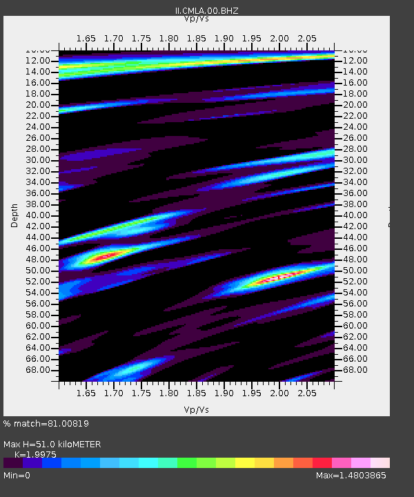
| Estimated Moho Depth: |
51.0 km |
| Estimated Crust Vp/Vs: |
2.00 |
| Assumed Crust Vp: |
4.802 km/s |
| Estimated Crust Vs: |
2.404 km/s |
| Estimated Crust Poisson's Ratio: |
0.33 |
|
| Radial Match: |
81.00819 % |
| Radial Bump: |
391 |
| Transverse Match: |
82.190315 % |
| Transverse Bump: |
400 |
| SOD ConfigId: |
558545 |
| Insert Time: |
2013-09-17 16:47:31.214 +0000 |
| GWidth: |
2.5 |
| Max Bumps: |
400 |
| Tol: |
0.001 |
|

Signal To Noise
| Channel | StoN | STA | LTA |
| II:CMLA:00:BHZ:20120811T12:32:22.419004Z | 10.001546 | 2.7863896E-6 | 2.785959E-7 |
| II:CMLA:00:BH1:20120811T12:32:22.419004Z | 1.2835039 | 8.950873E-7 | 6.973779E-7 |
| II:CMLA:00:BH2:20120811T12:32:22.419004Z | 1.3891543 | 7.415864E-7 | 5.338402E-7 |
| Arrivals |
| Ps | 11 SECOND |
| PpPs | 31 SECOND |
| PsPs/PpSs | 42 SECOND |


