You are here: Home > Network List > US - United States National Seismic Network Stations List
> Station LONY Lake Ozonia, New York, USA > Earthquake Result Viewer
LONY Lake Ozonia, New York, USA - Earthquake Result Viewer
| Earthquake location: |
Armenia-Azerbaijan-Iran Bord Reg |
| Earthquake latitude/longitude: |
38.3/46.8 |
| Earthquake time(UTC): |
2012/08/11 (224) 12:23:18 GMT |
| Earthquake Depth: |
11 km |
| Earthquake Magnitude: |
6.4 MW, 6.2 MB, 6.4 MW, 6.7 MS |
| Earthquake Catalog/Contributor: |
NEIC PDE/NEIC PDE-W |
|
| Network: |
US United States National Seismic Network |
| Station: |
LONY Lake Ozonia, New York, USA |
| Lat/Lon: |
44.62 N/74.58 W |
| Elevation: |
440 m |
|
| Distance: |
82.0 deg |
| Az: |
322.01 deg |
| Baz: |
42.678 deg |
| Ray Param: |
0.0472083 |
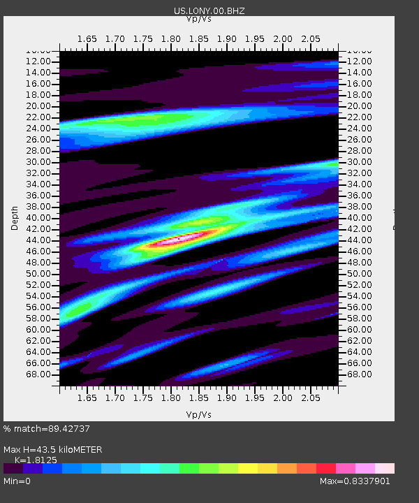
| Estimated Moho Depth: |
43.5 km |
| Estimated Crust Vp/Vs: |
1.81 |
| Assumed Crust Vp: |
6.419 km/s |
| Estimated Crust Vs: |
3.542 km/s |
| Estimated Crust Poisson's Ratio: |
0.28 |
|
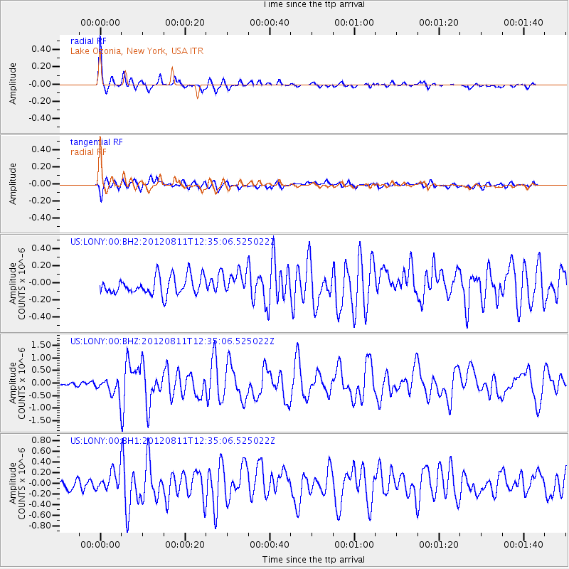
| Radial Match: |
89.42737 % |
| Radial Bump: |
322 |
| Transverse Match: |
74.42835 % |
| Transverse Bump: |
400 |
| SOD ConfigId: |
558545 |
| Insert Time: |
2013-09-17 16:50:37.680 +0000 |
| GWidth: |
2.5 |
| Max Bumps: |
400 |
| Tol: |
0.001 |
|
Signal To Noise
| Channel | StoN | STA | LTA |
| US:LONY:00:BHZ:20120811T12:35:06.525022Z | 3.043381 | 3.7314933E-7 | 1.2261012E-7 |
| US:LONY:00:BH1:20120811T12:35:06.525022Z | 2.3395422 | 1.8318546E-7 | 7.8299706E-8 |
| US:LONY:00:BH2:20120811T12:35:06.525022Z | 1.26944 | 1.323945E-7 | 1.0429363E-7 |
| Arrivals |
| Ps | 5.7 SECOND |
| PpPs | 19 SECOND |
| PsPs/PpSs | 24 SECOND |


