You are here: Home > Network List > US - United States National Seismic Network Stations List
> Station MCWV Mont Chateau, West Virginia, USA > Earthquake Result Viewer
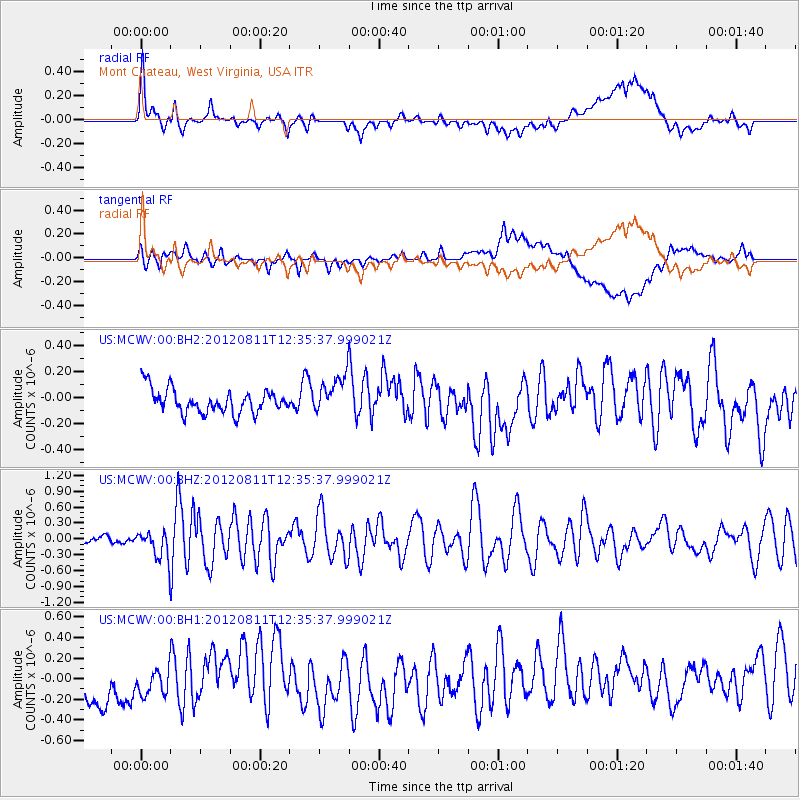
MCWV Mont Chateau, West Virginia, USA - Earthquake Result Viewer
*The percent match for this event was below the threshold and hence no stack was calculated.
| Earthquake location: |
Armenia-Azerbaijan-Iran Bord Reg |
| Earthquake latitude/longitude: |
38.3/46.8 |
| Earthquake time(UTC): |
2012/08/11 (224) 12:23:18 GMT |
| Earthquake Depth: |
11 km |
| Earthquake Magnitude: |
6.4 MW, 6.2 MB, 6.4 MW, 6.7 MS |
| Earthquake Catalog/Contributor: |
NEIC PDE/NEIC PDE-W |
|
| Network: |
US United States National Seismic Network |
| Station: |
MCWV Mont Chateau, West Virginia, USA |
| Lat/Lon: |
39.66 N/79.85 W |
| Elevation: |
280 m |
|
| Distance: |
88.3 deg |
| Az: |
321.724 deg |
| Baz: |
39.131 deg |
| Ray Param: |
$rayparam |
*The percent match for this event was below the threshold and hence was not used in the summary stack. |
|
| Radial Match: |
51.891518 % |
| Radial Bump: |
400 |
| Transverse Match: |
50.29028 % |
| Transverse Bump: |
400 |
| SOD ConfigId: |
558545 |
| Insert Time: |
2013-09-17 16:50:43.338 +0000 |
| GWidth: |
2.5 |
| Max Bumps: |
400 |
| Tol: |
0.001 |
|
Signal To Noise
| Channel | StoN | STA | LTA |
| US:MCWV:00:BHZ:20120811T12:35:37.999021Z | 3.0219786 | 2.6479478E-7 | 8.762298E-8 |
| US:MCWV:00:BH1:20120811T12:35:37.999021Z | 0.6869662 | 3.2243736E-7 | 4.6936424E-7 |
| US:MCWV:00:BH2:20120811T12:35:37.999021Z | 1.6063757 | 1.4584357E-7 | 9.079045E-8 |
| Arrivals |
| Ps | |
| PpPs | |
| PsPs/PpSs | |


