You are here: Home > Network List > US - United States National Seismic Network Stations List
> Station WRAK Wrangell Island, Southeastern Alaska, Alaska, USA > Earthquake Result Viewer
WRAK Wrangell Island, Southeastern Alaska, Alaska, USA - Earthquake Result Viewer
| Earthquake location: |
Armenia-Azerbaijan-Iran Bord Reg |
| Earthquake latitude/longitude: |
38.3/46.8 |
| Earthquake time(UTC): |
2012/08/11 (224) 12:23:18 GMT |
| Earthquake Depth: |
11 km |
| Earthquake Magnitude: |
6.4 MW, 6.2 MB, 6.4 MW, 6.7 MS |
| Earthquake Catalog/Contributor: |
NEIC PDE/NEIC PDE-W |
|
| Network: |
US United States National Seismic Network |
| Station: |
WRAK Wrangell Island, Southeastern Alaska, Alaska, USA |
| Lat/Lon: |
56.42 N/132.35 W |
| Elevation: |
81 m |
|
| Distance: |
85.6 deg |
| Az: |
359.539 deg |
| Baz: |
0.653 deg |
| Ray Param: |
0.044636406 |
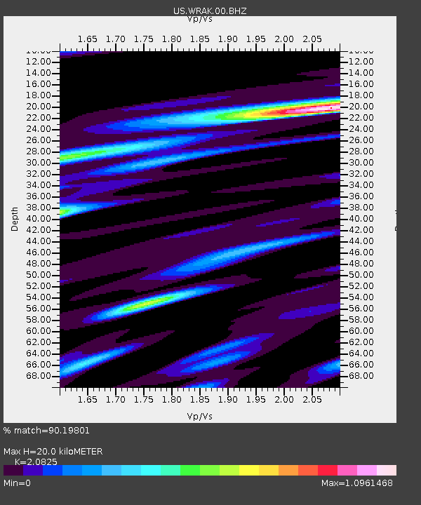
| Estimated Moho Depth: |
20.0 km |
| Estimated Crust Vp/Vs: |
2.08 |
| Assumed Crust Vp: |
6.597 km/s |
| Estimated Crust Vs: |
3.168 km/s |
| Estimated Crust Poisson's Ratio: |
0.35 |
|
| Radial Match: |
90.19801 % |
| Radial Bump: |
400 |
| Transverse Match: |
80.23579 % |
| Transverse Bump: |
400 |
| SOD ConfigId: |
558545 |
| Insert Time: |
2013-09-17 16:51:13.510 +0000 |
| GWidth: |
2.5 |
| Max Bumps: |
400 |
| Tol: |
0.001 |
|

Signal To Noise
| Channel | StoN | STA | LTA |
| US:WRAK:00:BHZ:20120811T12:35:25.073972Z | 2.1192014 | 2.3325421E-7 | 1.1006704E-7 |
| US:WRAK:00:BH1:20120811T12:35:25.073972Z | 1.7817343 | 9.30485E-8 | 5.222355E-8 |
| US:WRAK:00:BH2:20120811T12:35:25.073972Z | 1.0948076 | 9.95434E-8 | 9.0923194E-8 |
| Arrivals |
| Ps | 3.4 SECOND |
| PpPs | 9.1 SECOND |
| PsPs/PpSs | 12 SECOND |


