You are here: Home > Network List > IU - Global Seismograph Network (GSN - IRIS/USGS) Stations List
> Station GUMO Guam, Mariana Islands > Earthquake Result Viewer
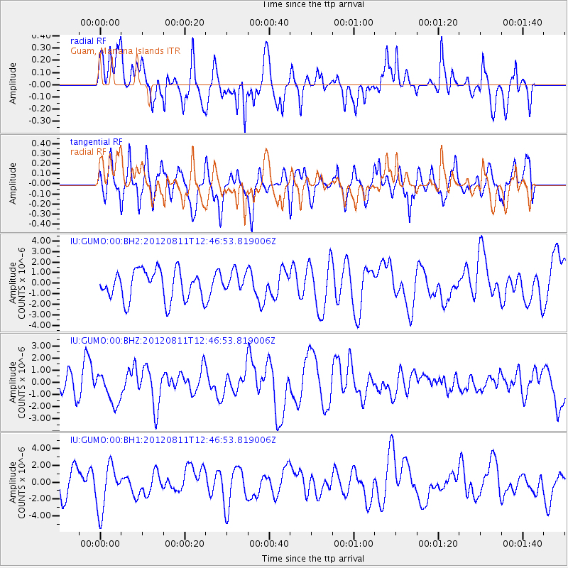
GUMO Guam, Mariana Islands - Earthquake Result Viewer
*The percent match for this event was below the threshold and hence no stack was calculated.
| Earthquake location: |
Armenia-Azerbaijan-Iran Bord Reg |
| Earthquake latitude/longitude: |
38.4/46.7 |
| Earthquake time(UTC): |
2012/08/11 (224) 12:34:35 GMT |
| Earthquake Depth: |
12 km |
| Earthquake Magnitude: |
6.3 MW, 6.2 MW, 6.3 MB |
| Earthquake Catalog/Contributor: |
NEIC PDE/NEIC PDE-W |
|
| Network: |
IU Global Seismograph Network (GSN - IRIS/USGS) |
| Station: |
GUMO Guam, Mariana Islands |
| Lat/Lon: |
13.59 N/144.87 E |
| Elevation: |
170 m |
|
| Distance: |
87.9 deg |
| Az: |
74.418 deg |
| Baz: |
308.879 deg |
| Ray Param: |
$rayparam |
*The percent match for this event was below the threshold and hence was not used in the summary stack. |
|
| Radial Match: |
70.287994 % |
| Radial Bump: |
400 |
| Transverse Match: |
47.723637 % |
| Transverse Bump: |
400 |
| SOD ConfigId: |
558545 |
| Insert Time: |
2013-09-17 16:52:50.767 +0000 |
| GWidth: |
2.5 |
| Max Bumps: |
400 |
| Tol: |
0.001 |
|
Signal To Noise
| Channel | StoN | STA | LTA |
| IU:GUMO:00:BHZ:20120811T12:46:53.819006Z | 1.8767623 | 1.2894113E-6 | 6.870403E-7 |
| IU:GUMO:00:BH1:20120811T12:46:53.819006Z | 1.4774795 | 2.7978747E-6 | 1.8936809E-6 |
| IU:GUMO:00:BH2:20120811T12:46:53.819006Z | 0.6911578 | 9.692325E-7 | 1.4023317E-6 |
| Arrivals |
| Ps | |
| PpPs | |
| PsPs/PpSs | |


