You are here: Home > Network List > US - United States National Seismic Network Stations List
> Station DGMT Dagmar, Montana, USA > Earthquake Result Viewer
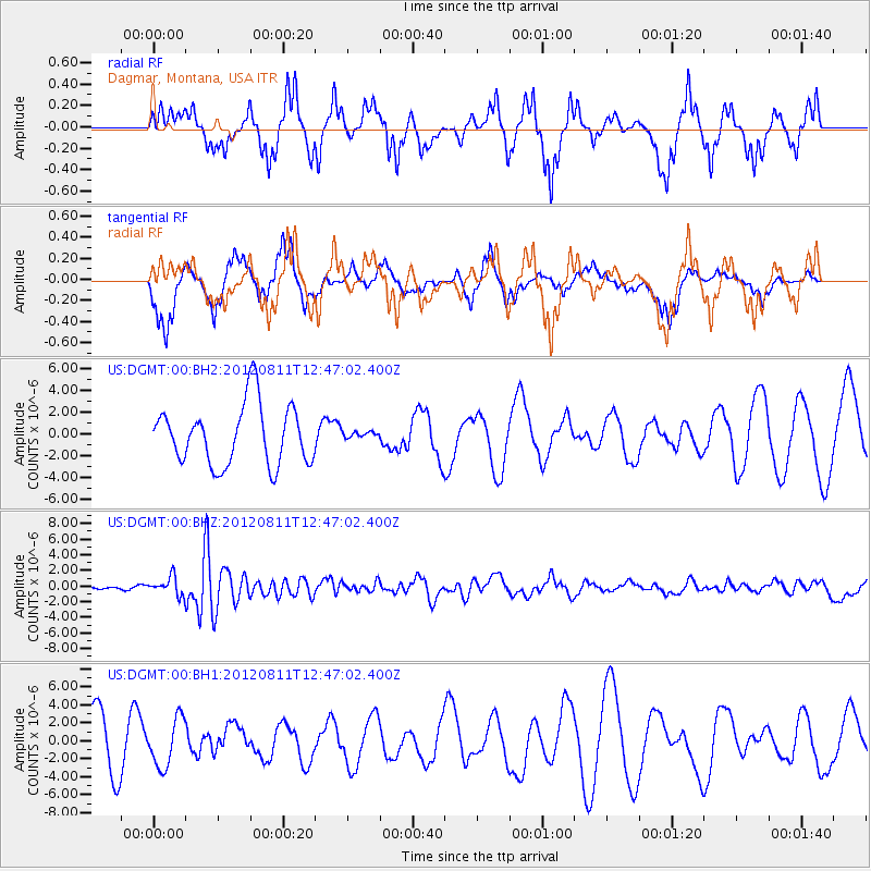
DGMT Dagmar, Montana, USA - Earthquake Result Viewer
*The percent match for this event was below the threshold and hence no stack was calculated.
| Earthquake location: |
Armenia-Azerbaijan-Iran Bord Reg |
| Earthquake latitude/longitude: |
38.4/46.7 |
| Earthquake time(UTC): |
2012/08/11 (224) 12:34:35 GMT |
| Earthquake Depth: |
12 km |
| Earthquake Magnitude: |
6.3 MW, 6.2 MW, 6.3 MB |
| Earthquake Catalog/Contributor: |
NEIC PDE/NEIC PDE-W |
|
| Network: |
US United States National Seismic Network |
| Station: |
DGMT Dagmar, Montana, USA |
| Lat/Lon: |
48.47 N/104.20 W |
| Elevation: |
0.0 m |
|
| Distance: |
89.7 deg |
| Az: |
341.14 deg |
| Baz: |
22.439 deg |
| Ray Param: |
$rayparam |
*The percent match for this event was below the threshold and hence was not used in the summary stack. |
|
| Radial Match: |
44.305443 % |
| Radial Bump: |
288 |
| Transverse Match: |
58.48999 % |
| Transverse Bump: |
275 |
| SOD ConfigId: |
558545 |
| Insert Time: |
2013-09-17 16:54:15.701 +0000 |
| GWidth: |
2.5 |
| Max Bumps: |
400 |
| Tol: |
0.001 |
|
Signal To Noise
| Channel | StoN | STA | LTA |
| US:DGMT:00:BHZ:20120811T12:47:02.400Z | 2.4507859 | 1.1601081E-6 | 4.7336167E-7 |
| US:DGMT:00:BH1:20120811T12:47:02.400Z | 0.89686555 | 2.6467683E-6 | 2.9511316E-6 |
| US:DGMT:00:BH2:20120811T12:47:02.400Z | 0.12309623 | 3.3675528E-7 | 2.7357078E-6 |
| Arrivals |
| Ps | |
| PpPs | |
| PsPs/PpSs | |


