You are here: Home > Network List > US - United States National Seismic Network Stations List
> Station EGMT Eagleton, Montana, USA > Earthquake Result Viewer
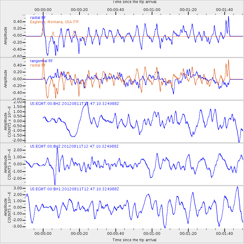
EGMT Eagleton, Montana, USA - Earthquake Result Viewer
*The percent match for this event was below the threshold and hence no stack was calculated.
| Earthquake location: |
Armenia-Azerbaijan-Iran Bord Reg |
| Earthquake latitude/longitude: |
38.4/46.7 |
| Earthquake time(UTC): |
2012/08/11 (224) 12:34:35 GMT |
| Earthquake Depth: |
12 km |
| Earthquake Magnitude: |
6.3 MW, 6.2 MW, 6.3 MB |
| Earthquake Catalog/Contributor: |
NEIC PDE/NEIC PDE-W |
|
| Network: |
US United States National Seismic Network |
| Station: |
EGMT Eagleton, Montana, USA |
| Lat/Lon: |
48.02 N/109.75 W |
| Elevation: |
1055 m |
|
| Distance: |
91.5 deg |
| Az: |
344.468 deg |
| Baz: |
18.268 deg |
| Ray Param: |
$rayparam |
*The percent match for this event was below the threshold and hence was not used in the summary stack. |
|
| Radial Match: |
60.045303 % |
| Radial Bump: |
400 |
| Transverse Match: |
50.243435 % |
| Transverse Bump: |
400 |
| SOD ConfigId: |
558545 |
| Insert Time: |
2013-09-17 16:54:22.626 +0000 |
| GWidth: |
2.5 |
| Max Bumps: |
400 |
| Tol: |
0.001 |
|
Signal To Noise
| Channel | StoN | STA | LTA |
| US:EGMT:00:BHZ:20120811T12:47:10.324988Z | 1.7587093 | 3.973483E-7 | 2.2593176E-7 |
| US:EGMT:00:BH1:20120811T12:47:10.324988Z | 0.2676557 | 2.1893938E-7 | 8.179889E-7 |
| US:EGMT:00:BH2:20120811T12:47:10.324988Z | 0.42567512 | 3.928849E-7 | 9.229689E-7 |
| Arrivals |
| Ps | |
| PpPs | |
| PsPs/PpSs | |


