You are here: Home > Network List > US - United States National Seismic Network Stations List
> Station HAWA Hanford, Washington, USA > Earthquake Result Viewer
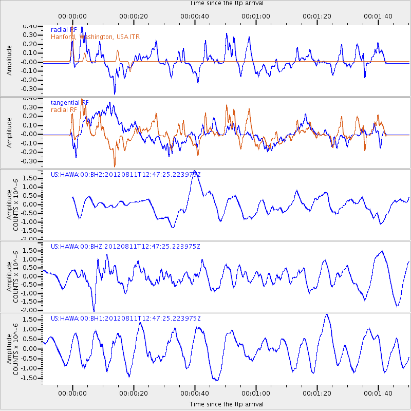
HAWA Hanford, Washington, USA - Earthquake Result Viewer
*The percent match for this event was below the threshold and hence no stack was calculated.
| Earthquake location: |
Armenia-Azerbaijan-Iran Bord Reg |
| Earthquake latitude/longitude: |
38.4/46.7 |
| Earthquake time(UTC): |
2012/08/11 (224) 12:34:35 GMT |
| Earthquake Depth: |
12 km |
| Earthquake Magnitude: |
6.3 MW, 6.2 MW, 6.3 MB |
| Earthquake Catalog/Contributor: |
NEIC PDE/NEIC PDE-W |
|
| Network: |
US United States National Seismic Network |
| Station: |
HAWA Hanford, Washington, USA |
| Lat/Lon: |
46.39 N/119.53 W |
| Elevation: |
364 m |
|
| Distance: |
94.7 deg |
| Az: |
350.518 deg |
| Baz: |
10.78 deg |
| Ray Param: |
$rayparam |
*The percent match for this event was below the threshold and hence was not used in the summary stack. |
|
| Radial Match: |
45.066303 % |
| Radial Bump: |
400 |
| Transverse Match: |
45.234425 % |
| Transverse Bump: |
400 |
| SOD ConfigId: |
558545 |
| Insert Time: |
2013-09-17 16:54:37.100 +0000 |
| GWidth: |
2.5 |
| Max Bumps: |
400 |
| Tol: |
0.001 |
|
Signal To Noise
| Channel | StoN | STA | LTA |
| US:HAWA:00:BHZ:20120811T12:47:25.223975Z | 0.9173502 | 2.5404546E-7 | 2.76934E-7 |
| US:HAWA:00:BH1:20120811T12:47:25.223975Z | 1.3914636 | 6.2283704E-7 | 4.4761285E-7 |
| US:HAWA:00:BH2:20120811T12:47:25.223975Z | 3.8698173 | 9.684253E-7 | 2.5025093E-7 |
| Arrivals |
| Ps | |
| PpPs | |
| PsPs/PpSs | |


