You are here: Home > Network List > IU - Global Seismograph Network (GSN - IRIS/USGS) Stations List
> Station KONO Kongsberg, Norway > Earthquake Result Viewer
KONO Kongsberg, Norway - Earthquake Result Viewer

| Earthquake location: |
Xizang |
| Earthquake latitude/longitude: |
35.7/82.5 |
| Earthquake time(UTC): |
2012/08/12 (225) 10:47:06 GMT |
| Earthquake Depth: |
13 km |
| Earthquake Magnitude: |
6.1 MB, 6.1 MS, 6.2 MW, 6.3 MW |
| Earthquake Catalog/Contributor: |
WHDF/NEIC |
|
| Network: |
IU Global Seismograph Network (GSN - IRIS/USGS) |
| Station: |
KONO Kongsberg, Norway |
| Lat/Lon: |
59.65 N/9.60 E |
| Elevation: |
216 m |
|
| Distance: |
51.6 deg |
| Az: |
321.713 deg |
| Baz: |
83.499 deg |
| Ray Param: |
0.067316145 |
| Estimated Moho Depth: |
29.5 km |
| Estimated Crust Vp/Vs: |
1.91 |
| Assumed Crust Vp: |
6.545 km/s |
| Estimated Crust Vs: |
3.427 km/s |
| Estimated Crust Poisson's Ratio: |
0.31 |
|
| Radial Match: |
92.7968 % |
| Radial Bump: |
400 |
| Transverse Match: |
77.648315 % |
| Transverse Bump: |
400 |
| SOD ConfigId: |
558545 |
| Insert Time: |
2013-09-17 16:57:34.929 +0000 |
| GWidth: |
2.5 |
| Max Bumps: |
400 |
| Tol: |
0.001 |
|
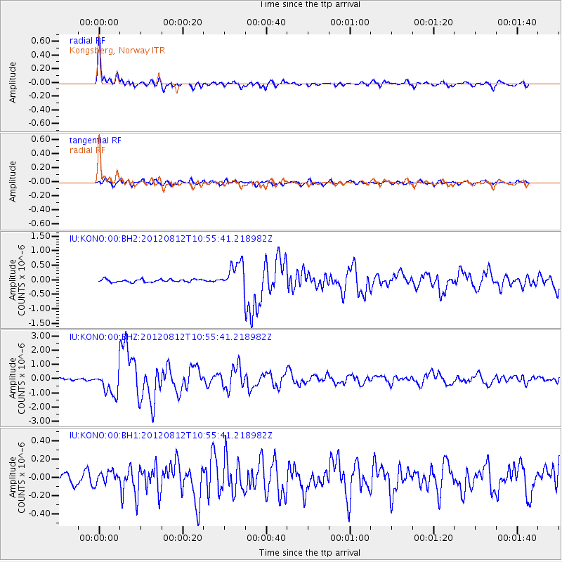
Signal To Noise
| Channel | StoN | STA | LTA |
| IU:KONO:00:BHZ:20120812T10:55:41.218982Z | 10.382168 | 8.623928E-7 | 8.306481E-8 |
| IU:KONO:00:BH1:20120812T10:55:41.218982Z | 1.1184319 | 6.2111376E-8 | 5.553434E-8 |
| IU:KONO:00:BH2:20120812T10:55:41.218982Z | 9.642606 | 4.611537E-7 | 4.782459E-8 |
| Arrivals |
| Ps | 4.3 SECOND |
| PpPs | 12 SECOND |
| PsPs/PpSs | 17 SECOND |


