You are here: Home > Network List > GS - US Geological Survey Networks Stations List
> Station DEC08 Union Local 159 Surface Site > Earthquake Result Viewer
DEC08 Union Local 159 Surface Site - Earthquake Result Viewer
*The percent match for this event was below the threshold and hence no stack was calculated.
| Earthquake location: |
Gulf Of Alaska |
| Earthquake latitude/longitude: |
59.2/-145.6 |
| Earthquake time(UTC): |
2014/08/27 (239) 06:10:19 GMT |
| Earthquake Depth: |
12 km |
| Earthquake Magnitude: |
5.1 Mww, 4.8 ML, 5.0 mb, 4.7 Ms_20 |
| Earthquake Catalog/Contributor: |
ISC/ISC |
|
| Network: |
GS US Geological Survey Networks |
| Station: |
DEC08 Union Local 159 Surface Site |
| Lat/Lon: |
39.86 N/88.92 W |
| Elevation: |
210 m |
|
| Distance: |
40.1 deg |
| Az: |
93.084 deg |
| Baz: |
318.154 deg |
| Ray Param: |
$rayparam |
*The percent match for this event was below the threshold and hence was not used in the summary stack. |
|
| Radial Match: |
70.07305 % |
| Radial Bump: |
400 |
| Transverse Match: |
45.644897 % |
| Transverse Bump: |
400 |
| SOD ConfigId: |
3390531 |
| Insert Time: |
2019-04-13 15:54:42.809 +0000 |
| GWidth: |
2.5 |
| Max Bumps: |
400 |
| Tol: |
0.001 |
|
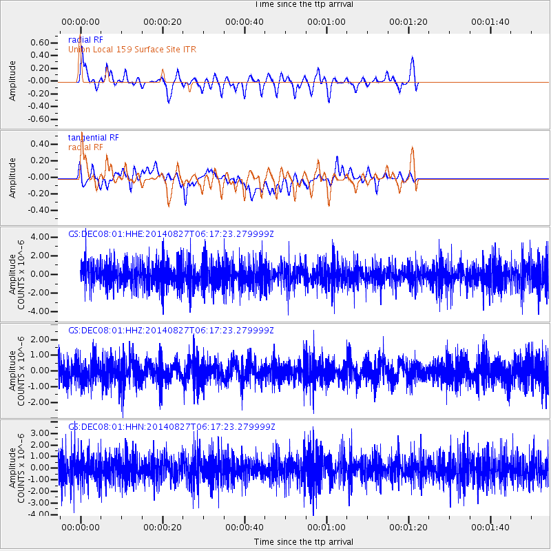
Signal To Noise
| Channel | StoN | STA | LTA |
| GS:DEC08:01:HHZ:20140827T06:17:23.279999Z | 0.7396154 | 7.814911E-7 | 1.0566183E-6 |
| GS:DEC08:01:HHN:20140827T06:17:23.279999Z | 0.86656845 | 1.1367083E-6 | 1.3117352E-6 |
| GS:DEC08:01:HHE:20140827T06:17:23.279999Z | 1.0498209 | 1.3566329E-6 | 1.2922517E-6 |
| Arrivals |
| Ps | |
| PpPs | |
| PsPs/PpSs | |


